IMAGES TAKEN NEAR TO
Badger Edge, ME10 4FZ
Introduction
This page details the photographs taken nearby to Badger Edge, ME10 4FZ by members of the Geograph project.
The Geograph project started in 2005 with the aim of publishing, organising and preserving representative images for every square kilometre of Great Britain, Ireland and the Isle of Man.

There are currently over 7.5m images from over14,400 individuals and you can help contribute to the project by visiting https://www.geograph.org.uk
Image Map
Images are licensed for reuse under creativecommons.org/licenses/by-sa/2.0
Notes
- Clicking on the map will re-center to the selected point.
- The higher the marker number, the further away the image location is from the centre of the postcode.
Image Listing (28 Images Found)
Images are licensed for reuse under creativecommons.org/licenses/by-sa/2.0
Image
Details
Distance
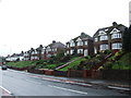
1
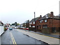
Blossom Street
Part of a housing estate, under construction, called Spring Acres.
Image: © John Baker
Taken: 1 Mar 2023
0.07 miles
2
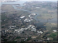
Sittingbourne from the air
Sittingbourne in the foreground with Kingsferry Bridge and the Sheppey Crossing over Long Reach to the Isle of Sheppey beyond. The River Medway and part of the Isle of Grain can also be seen. Viewed through thin cloud from a Gatwick bound flight from Prague.
Image: © Thomas Nugent
Taken: 28 Jan 2022
0.07 miles
3
Blossom Street
Part of a housing estate, under construction, called Spring Acres.
Image: © John Baker
Taken: 1 Mar 2023
0.07 miles
4

Old Milestone by the A2, Canterbury Road, Sittingbourne parish
Metal plates attached to stone post by the A2, in parish of SITTINGBOURNE (SWALE District), Canterbury Road, by No. 201 "The Milestone", back of pavement, set in low stone boundary wall, on North side of road. Dover Road facet, erected by the Chatham & Canterbury turnpike trust in the 19th century.
Inscription reads:-
: 14 / MILES / TO / CANTERBURY : : 41 / MILES / TO / LONDON :
Milestone Society National ID: KE_LD41.
Image: © C Woodward
Taken: 12 Jul 2007
0.11 miles
6
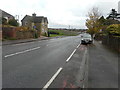
Fox Hill
Just beyond the house, on the left, a fence has been erected stretching far into the distance. This encloses farmland, once belonging to Stones Farm, which is going to be developed.
Planning permission has been granted by Swale Borough Council under application number 14/501588/OUT for a “hybrid application (part outline, part approval of detail) consisting of: outline application for the development of 550-600 houses and all necessary supporting infrastructure including roads, open space, play areas, neighbourhood shopping/community facilities (up to 650 sq m gross) and landscaping. All detailed matters are reserved for subsequent approval except (i) vehicular access to A2 Fox Hill; (ii) emergency access to Peel Drive; (iii) landscape buffer between housing and countryside gap and (iv) layout, planting, biodiversity enhancement and management of countryside gap, as amended by drawings 5257/OPA/SK001 Rev J (new red line plan), D119/52 (Swanstree Avenue plan) and D119/53 (junction layout plan)”.
Image: © John Baker
Taken: 2 Dec 2018
0.12 miles
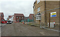
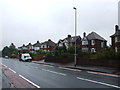
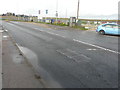
8
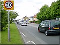
Eastern Approach to Sittingbourne
The A2 Canterbury Road on the eastern edge of Sittingbourne as it heads up Fox Hill. The road is based upon the Roman Watling Street and is very straight which tempts drivers to speed violations. The 30mph limit has been extended eastwards and a speed camera installed.
Image: © Penny Mayes
Taken: 17 May 2005
0.16 miles
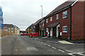
9
Development land
Planning permission has been granted by Swale Borough Council under application number 14/501588/OUT for a “hybrid application (part outline, part approval of detail) consisting of: outline application for the development of 550-600 houses and all necessary supporting infrastructure including roads, open space, play areas, neighbourhood shopping/community facilities (up to 650 sq m gross) and landscaping. All detailed matters are reserved for subsequent approval except (i) vehicular access to A2 Fox Hill; (ii) emergency access to Peel Drive; (iii) landscape buffer between housing and countryside gap and (iv) layout, planting, biodiversity enhancement and management of countryside gap, as amended by drawings 5257/OPA/SK001 Rev J (new red line plan), D119/52 (Swanstree Avenue plan) and D119/53 (junction layout plan)”.
This is the site viewed from Image, which is to be built on farmland, once belonging to Stones Farm.
Image: © John Baker
Taken: 2 Dec 2018
0.17 miles