IMAGES TAKEN NEAR TO
Fairlake View, ME10 3TX
Introduction
This page details the photographs taken nearby to Fairlake View, ME10 3TX by members of the Geograph project.
The Geograph project started in 2005 with the aim of publishing, organising and preserving representative images for every square kilometre of Great Britain, Ireland and the Isle of Man.

There are currently over 7.5m images from over14,400 individuals and you can help contribute to the project by visiting https://www.geograph.org.uk
Image Map
Images are licensed for reuse under creativecommons.org/licenses/by-sa/2.0
Notes
- Clicking on the map will re-center to the selected point.
- The higher the marker number, the further away the image location is from the centre of the postcode.
Image Listing (12 Images Found)
Images are licensed for reuse under creativecommons.org/licenses/by-sa/2.0
Image
Details
Distance
1
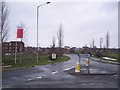
Entrance to Great East Hall Development
Seen from the roundabout on Swale Way. Mulberry Road leads into the estate. Some houses have been finished, but more are still to be built. Currently, this is the only way in and out (by car).
Image: © David Anstiss
Taken: 16 Jan 2010
0.05 miles
2
Great Easthill Way
This is currently an access road for construction traffic working on the great East Hall housing development. Eventually this will be a road through the large estate. Seen from Swale Way.
Image: © David Anstiss
Taken: 16 Jan 2010
0.08 miles
3
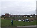
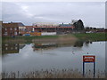
Great Easthall pond
This large pond is also used as a drainage reservoir within the Great Easthall housing estate. Some of the houses in the estate are now occupied.
Image: © David Anstiss
Taken: 16 Feb 2013
0.09 miles
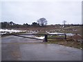
4
Road for construction traffic only
The Great Easthall part of the big development expanding Sittingbourne eastwards.
Image: © Robin Webster
Taken: 21 Mar 2017
0.09 miles
5
Great Easthall pond
This large pond is also used as a drainage reservoir within the Great Easthall housing estate. Some of the houses in the estate are now occupied but others are still under construction.
Image: © David Anstiss
Taken: 16 Feb 2013
0.10 miles
6
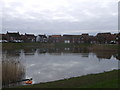
Great Easthall pond
This large pond is also used as a drainage reservoir within the Great Easthall housing estate. Some of the houses in the estate are now occupied.
In the background is Mulberry Way.
Image: © David Anstiss
Taken: 16 Feb 2013
0.11 miles
7
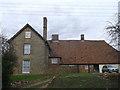
East Hall, Sittingbourne (2)
This Grade II listed building is on Meeres Court Lane.
See http://www.britishlistedbuildings.co.uk/en-175802-east-hall-kent for more details about the listed farmhouse.
Image: © David Anstiss
Taken: 16 Feb 2013
0.12 miles
8
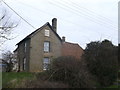
East Hall, Sittingbourne
This Grade II listed building is on Meeres Court Lane.
See http://www.britishlistedbuildings.co.uk/en-175802-east-hall-kent for more details about the listed farmhouse.
Image: © David Anstiss
Taken: 16 Feb 2013
0.12 miles
9
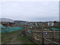
Meres Court Lane allotments, Sittingbourne
This block of garden plots is between the lane (towards Meres Court Farm) and Eurolink East Industrial Estate (on the left).
Image: © David Anstiss
Taken: 16 Feb 2013
0.16 miles
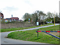
10

Eveas Drive, Great Easthall Estate
As seen from the junction with Mulberry Way.
Image: © David Anstiss
Taken: 16 Feb 2013
0.22 miles