IMAGES TAKEN NEAR TO
Castle Road, SITTINGBOURNE, ME10 3NB
Introduction
This page details the photographs taken nearby to Castle Road, ME10 3NB by members of the Geograph project.
The Geograph project started in 2005 with the aim of publishing, organising and preserving representative images for every square kilometre of Great Britain, Ireland and the Isle of Man.

There are currently over 7.5m images from over14,400 individuals and you can help contribute to the project by visiting https://www.geograph.org.uk
Image Map
Images are licensed for reuse under creativecommons.org/licenses/by-sa/2.0
Notes
- Clicking on the map will re-center to the selected point.
- The higher the marker number, the further away the image location is from the centre of the postcode.
Image Listing (50 Images Found)
Images are licensed for reuse under creativecommons.org/licenses/by-sa/2.0
Image
Details
Distance
2
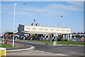
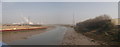
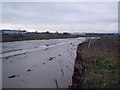
The Northern Relief Road Bridge construction works in Milton Creek
The new road from Kemsley heads towards the Eurolink Industrial Estate near Sittingbourne, it heads over the Creek.
This follows Image
Image: © David Anstiss
Taken: 25 Dec 2010
0.09 miles
3
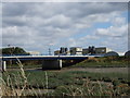
Swale Way bridge over Milton Creek near Sittingbourne
Image: © Chris Whippet
Taken: 15 Aug 2013
0.09 miles
4
Milton Creek to Kemsley
As seen from Image
This creek flows towards The Swale from Sittingbourne.
In the far background is Kemsley Paper Mill.
In the foreground is Church Wharf, where the Saxon Shore Way (long distance path) heads along the creek to Kemsley.
Image: © David Anstiss
Taken: 22 Mar 2012
0.09 miles
5
Milton Creek to Kemsley (panorama)
As seen from Image
This creek flows towards The Swale from Sittingbourne.
In the far background is Kemsley Paper Mill (the 4 chimneys).
On the left, is Church Wharf, where the Saxon Shore Way (long distance path) heads along the creek to Kemsley.
On the right, is the Eurolink Industrial Estate.
Image: © David Anstiss
Taken: 22 Mar 2012
0.09 miles
6
Bridge construction works in Milton Creek
The new road from Kemsley heads towards the Eurolink Industrial Estate near Sittingbourne, it heads over the Creek.
This follows Image
Image: © David Anstiss
Taken: 25 Dec 2010
0.10 miles
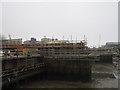
7
The route of the Northern Relief Road over Milton Creek
Construction has just started on the Relief Road from Kemsley (near the Paper Mill) through Kemsley Marshes and then over the creek to Castle Road within the Eurolink Industrial Estate. A gap in the warehouses has been left to accommodate the new bridge road. See http://kent.gov.uk/roads_and_transport/major_transport_schemes/current_schemes/sittingbourne_relief_road.aspx for more details on the road.
Image: © David Anstiss
Taken: 25 Dec 2009
0.10 miles
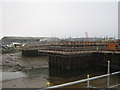
8
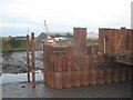
Sheet piles in the Milton Creek
The Sittingbourne Northern Relief Road, runs from Kemsley, then over the creek towards the Eurolink Industrial Estate (in the background, with the yellow crane). The sheet piles are drivn into the ground to make a dry and secure base for part of the creek bridge works. See also Image, for a wider shot.
The creek is at low tide.
Image: © David Anstiss
Taken: 30 Jun 2010
0.11 miles
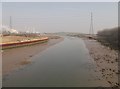
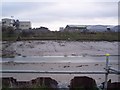
9
Milton Creek near Church Wharf
This creek leads from the Swale Strait into Sittingbourne. At this point the Northern Relief Road will crosses the creek towards the Eurolink Business Park (on the other side). Construction work on this road has just started. See http://kent.gov.uk/roads_and_transport/major_transport_schemes/current_schemes/sittingbourne_relief_road.aspx for more details on the link road.
Image: © David Anstiss
Taken: 25 Dec 2009
0.11 miles
10
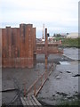
Boardwalk in the mud
The Sittingbourne Northern Relief Road, runs from Kemsley, then over the creek towards the Eurolink Industrial Estate (in the background, with the yellow crane). The sheet piles are drivn into the ground to make a dry and secure base for part of the creek bridge works. The walk is for workers to access the platform in the creek. The creek is at low tide.
See Image for a wider shot.
Image: © David Anstiss
Taken: 30 Jun 2010
0.11 miles