IMAGES TAKEN NEAR TO
Mill Way, SITTINGBOURNE, ME10 2WR
Introduction
This page details the photographs taken nearby to Mill Way, ME10 2WR by members of the Geograph project.
The Geograph project started in 2005 with the aim of publishing, organising and preserving representative images for every square kilometre of Great Britain, Ireland and the Isle of Man.

There are currently over 7.5m images from over14,400 individuals and you can help contribute to the project by visiting https://www.geograph.org.uk
Image Map
Images are licensed for reuse under creativecommons.org/licenses/by-sa/2.0
Notes
- Clicking on the map will re-center to the selected point.
- The higher the marker number, the further away the image location is from the centre of the postcode.
Image Listing (106 Images Found)
Images are licensed for reuse under creativecommons.org/licenses/by-sa/2.0
Image
Details
Distance
2
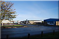
Iron Mountain, Mill Way
Information management company
Website: http://www.ironmountain.co.uk/index.asp
Image: © N Chadwick
Taken: 30 Oct 2010
0.04 miles
3

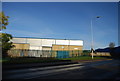
Yellow Poles on Gas Road
Here are the yellow poles on the perfect not so perfect Gas Road. They are placed there to protect the light railway from cars and also create bays for cars to give way.
Image: © Joe White
Taken: 14 Oct 2008
0.04 miles
5
Sittingbourne and Kemsley Light Railway over Gas Rd
Image: © N Chadwick
Taken: 30 Oct 2010
0.06 miles
6
Sittingbourne - 2015
Sittingbourne, Kent, Sittingbourne Steam Railway aka Sittingbourne & Kemsley Light Railway (S&KLR), Gas Road
Image: © Helmut Zozmann
Taken: 29 Jul 2015
0.06 miles
7
Sittingbourne - 2015
Sittingbourne, Kent, Sittingbourne Steam Railway aka Sittingbourne & Kemsley Light Railway (S&KLR), Gas Road
Image: © Helmut Zozmann
Taken: 29 Jul 2015
0.07 miles
8
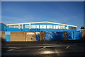
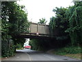
SKLR over Gas Road, North
Sittingbourne and Kemsley Light Railway, a conservation steam railway line goes from Sittingbourne to Kemsley Down, near papermill. Currently under threat of closure, due to papermill closure. See http://www.sklr.net for more details.
In background, Store Area for Milton Pipes, (on Roman Burial Ground).
Image: © David Anstiss
Taken: 4 Dec 2008
0.07 miles
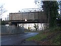
10
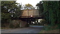
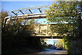
Low bridge, Gas Road, Sittingbourne
This bridge carries the Sittingbourne & Kemsley Light Railway across Gas Road. The warning sign gives the maximum safe height of 10'9" for passing beneath the bridge.
Image: © Malc McDonald
Taken: 7 Sep 2013
0.07 miles