IMAGES TAKEN NEAR TO
Walsby Drive, SITTINGBOURNE, ME10 2TU
Introduction
This page details the photographs taken nearby to Walsby Drive, ME10 2TU by members of the Geograph project.
The Geograph project started in 2005 with the aim of publishing, organising and preserving representative images for every square kilometre of Great Britain, Ireland and the Isle of Man.

There are currently over 7.5m images from over14,400 individuals and you can help contribute to the project by visiting https://www.geograph.org.uk
Image Map
Images are licensed for reuse under creativecommons.org/licenses/by-sa/2.0
Notes
- Clicking on the map will re-center to the selected point.
- The higher the marker number, the further away the image location is from the centre of the postcode.
Image Listing (97 Images Found)
Images are licensed for reuse under creativecommons.org/licenses/by-sa/2.0
Image
Details
Distance
1

Walsby Drive
2000s properties in Kemsley.
Image: © Burgess Von Thunen
Taken: 3 Jul 2012
0.04 miles
2
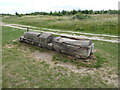
Carving at Milton Creek Country Park
Milton Creek Country Park consists of 128 acres of a former landfill site. The physical work of developing the Country Park actually began in 2003 with the capping of the landfill site. For more information about the Country Park see the website for https://miltoncreek.co.uk/
There is a Friends of Milton Creek - see https://miltoncreek.co.uk/about/the-friends/
Image: © Marathon
Taken: 27 Jun 2020
0.05 miles
3
Milton Creek Country Park
Milton Creek Country Park consists of 128 acres of a former landfill site. The physical work of developing the Country Park actually began in 2003 with the capping of the landfill site. For more information about the Country Park see the website for https://miltoncreek.co.uk/
There is a Friends of Milton Creek - see https://miltoncreek.co.uk/about/the-friends/
This photograph is taken from a high bank which arcs round on the inner edge of the Country Park.
Image: © Marathon
Taken: 27 Jun 2020
0.05 miles
4
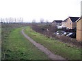
Footpath beside Church Milton Estate
This path leads on a earthwork embankment, this protects the housing from the flooding of Church Marshes (on the left) and the Milton Creek. The path leads from Recreation Way to Miller Close. Church Marshes is also a new country park being developed over time.
Image: © David Anstiss
Taken: 25 Dec 2009
0.06 miles
5
Milton Creek Country Park
Milton Creek Country Park consists of 128 acres of a former landfill site. The physical work of developing the Country Park actually began in 2003 with the capping of the landfill site. For more information about the Country Park see the website for https://miltoncreek.co.uk/
There is a Friends of Milton Creek - see https://miltoncreek.co.uk/about/the-friends/
This photograph is taken from a high bank which arcs round on the inner edge of the Country Park.
Image: © Marathon
Taken: 27 Jun 2020
0.06 miles
6
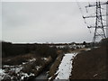
Kemsley
From the new Sittingbourne Northern Relief Road. Flood defences can be seen in front of the houses.
Image: © Burgess Von Thunen
Taken: 8 Feb 2012
0.06 miles
7
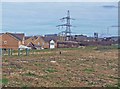
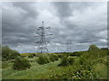
Church Marshes Country Park
Looking towards St Regis paper mill, Kemsley. The houses on the left are built "behind" a flood bund. The photographer position is on about a three metre depth of infill which has been brought here to "cover up" the former landfill tip on this site. The green plastic tubes protect newly planted trees and shrubs from rabbits.
Image: © Richard Dorrell
Taken: 2 Mar 2008
0.06 miles
8

Yeates Drive
2000s houses in Kemsley.
Image: © Burgess Von Thunen
Taken: 3 Jul 2012
0.06 miles
9
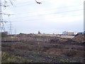
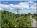
Construction of Northern Relief Road
Work has started on the construction of the new Northern Relief Road, which will bypass Sittingbourne town centre. It leads from the link road near Kemsley Paper Mill (seen in the background) through the Kemsley Marshes, past the Church Marshes Country Park towards the Milton Creek and then on to Castle Road within the Eurolink Business Park. See http://kent.gov.uk/roads_and_transport/major_transport_schemes/current_schemes/sittingbourne_relief_road.aspx for more details on the road.
Image: © David Anstiss
Taken: 25 Dec 2009
0.07 miles
10

Kemsley Marshes
Flood defences on the edge of Kemsley.
Image: © Burgess Von Thunen
Taken: 3 Jul 2012
0.07 miles