IMAGES TAKEN NEAR TO
Kingsmill Close, SITTINGBOURNE, ME10 2AZ
Introduction
This page details the photographs taken nearby to Kingsmill Close, ME10 2AZ by members of the Geograph project.
The Geograph project started in 2005 with the aim of publishing, organising and preserving representative images for every square kilometre of Great Britain, Ireland and the Isle of Man.

There are currently over 7.5m images from over14,400 individuals and you can help contribute to the project by visiting https://www.geograph.org.uk
Image Map
Images are licensed for reuse under creativecommons.org/licenses/by-sa/2.0
Notes
- Clicking on the map will re-center to the selected point.
- The higher the marker number, the further away the image location is from the centre of the postcode.
Image Listing (182 Images Found)
Images are licensed for reuse under creativecommons.org/licenses/by-sa/2.0
Image
Details
Distance
2
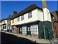
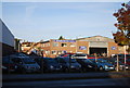
Former shops in High Street, Milton Regis
There are a surprising number of old buildings in Milton Regis. These have every appearance of having once been shops.
Image: © Marathon
Taken: 18 Jul 2021
0.04 miles
3
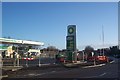
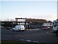
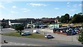
Construction of New BP Petrol Filling Station
This new station is on the roundabout junction on the B2005 Mill Way (on the right) and St Paul's Street (in front).
Image: © David Anstiss
Taken: 25 Nov 2003
0.04 miles
4
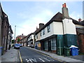
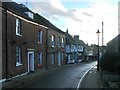
Milton Regis, High Street
Looking south, from the junction with Crown Road.
The water tower in the centre of the picture is at the now closed Sittingbourne paper mill. (See Image)
Image: © Richard Dorrell
Taken: 28 Mar 2008
0.06 miles
6
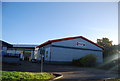
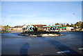
Roundabout on B2005 Mill Way, Sittingbourne
Busy junction with St Paul's Street (on right), coming from A249/Milton Regis.
Mill Way heading left leads to Kemsley/Iwade. Mill Way heading right leads to Sittingbourne Town Centre. Railway in background is the SKLR (Sittingbourne and Kemsley Light Railway),running from Sittingbourne to Kemsley Down, currently under threat of closure. See http://sklr.net for more details on the campaign to save the steam railway.
Image: © David Anstiss
Taken: 4 Dec 2008
0.07 miles
9
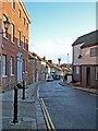
King Street, Sittingbourne
A short loop off Mill Way.
Image: © Christine Johnstone
Taken: 1 Aug 2018
0.07 miles