IMAGES TAKEN NEAR TO
Munday Street, MANCHESTER, M4 7AZ
Introduction
This page details the photographs taken nearby to Munday Street, M4 7AZ by members of the Geograph project.
The Geograph project started in 2005 with the aim of publishing, organising and preserving representative images for every square kilometre of Great Britain, Ireland and the Isle of Man.

There are currently over 7.5m images from over14,400 individuals and you can help contribute to the project by visiting https://www.geograph.org.uk
Image Map
Images are licensed for reuse under creativecommons.org/licenses/by-sa/2.0
Notes
- Clicking on the map will re-center to the selected point.
- The higher the marker number, the further away the image location is from the centre of the postcode.
Image Listing (418 Images Found)
Images are licensed for reuse under creativecommons.org/licenses/by-sa/2.0
Image
Details
Distance
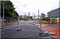
1
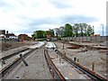
Manchester Metrolink construction between Munday Street and Merrill Street, Manchester
This is the Metrolink line going to Droylsden, and eventually Ashton-under-Lyne. Here it will run on its own private right of way, but when it reaches Merrill Street, it will run in the street, until again going onto its own right of way for a while. Photographed from the road crossing in Munday Street.
Image
Image: © P L Chadwick
Taken: 2 May 2010
0.01 miles
2
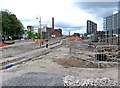
Manchester Metrolink construction near Pollard Street
A view of the work on the extension from Piccadilly to Droylsden & Ashton-under-Lyne in early May 2010. In this section, the tracks run on private right-of-way before running along the public highway in Merrill Street. Here the concrete bed has been prepared for one of the tracks.
Photographed from a temporary pedestrian crossing by Carruthers Street.
Image
Image: © P L Chadwick
Taken: 2 May 2010
0.01 miles
3
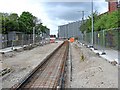
Manchester Metrolink construction near Merrill Street
Between Piccadilly Railway Station and Merrill Street, the new line to Droylsden & Ashton-under-Lyne will be on reserved track, free of other traffic. This section is looking in the direction of Munday Street. The line will cross that street, and there will be a tram stop on the Piccadilly side of Munday Street. This stop will be known as New Islington. That is the name applied to this much redeveloped area, which no doubt will still be known to many as Ancoats.
When this photograph was taken in early May 2010, only one line of rail had been laid at this point. A second will run alongside it.
Image
Image: © P L Chadwick
Taken: 2 May 2010
0.01 miles
4

Hat Box
The new 'Hat Box' development in New Islington.
Image: © Peter McDermott
Taken: 4 Jul 2015
0.02 miles
5

Metrolink Station, New Islington
Looking along the line of the tramway from Carruthers Street, the new Metrolink stop at New Islington looks to be completed. When it is opened, it will be the first stop on the new Piccadilly–Droylsden (and eventually Ashton) line. It is situated adjacent to Pollard Street (to the left in this photo).
Image: © David Dixon
Taken: 1 Sep 2012
0.02 miles
6
Pollard Street, Manchester
The newly laid Metro line goes off in the direction of Piccadilly
Image: © Alexander P Kapp
Taken: 25 Oct 2011
0.02 miles
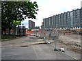
7
Manchester Metrolink construction by Pollard Street, Manchester
On the left is Pollard Street, and to the right is Carruthers Street. Ahead the tramway has been constructed on private right-of-way, as part of its route to Piccadilly Railway Station and Manchester's city centre. As the rails and overhead power lines have now been installed here, it is likely that testing of trams on this section will be carried out in the next few months.
The view a year earlier, in May 2010:- Image
Image: © P L Chadwick
Taken: 7 May 2011
0.03 miles
8
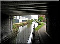
Ashton Canal passing under Carruthers Street Bridge
The canal here is flanked by both new and old buildings.
Image
Image: © P L Chadwick
Taken: 2 May 2010
0.03 miles
9
Manchester Metrolink crossing Carruthers Street, Manchester
The tramway crosses Carruthers Street and then continues street running along Merrill Street (to the left in this view). The overhead power lines have already been installed here. Test running of trams along this section is likely to start in the next few months.
Image
Image: © P L Chadwick
Taken: 7 May 2011
0.03 miles
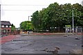
10
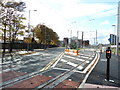
Pollard Street near Carruthers Street
A large section of Pollard Street was fenced off, when this photograph was taken in May 2010. This was to facilitate tram track laying for Manchester Metrolink's extension to Droylsden, and later to Ashton-under-Lyne. On the corner are part of the grounds of St. Anne's Roman Catholic Primary School.
Image: © P L Chadwick
Taken: 2 May 2010
0.03 miles