IMAGES TAKEN NEAR TO
Hardy Lane, MANCHESTER, M21 8DN
Introduction
This page details the photographs taken nearby to Hardy Lane, M21 8DN by members of the Geograph project.
The Geograph project started in 2005 with the aim of publishing, organising and preserving representative images for every square kilometre of Great Britain, Ireland and the Isle of Man.

There are currently over 7.5m images from over14,400 individuals and you can help contribute to the project by visiting https://www.geograph.org.uk
Image Map
Images are licensed for reuse under creativecommons.org/licenses/by-sa/2.0
Notes
- Clicking on the map will re-center to the selected point.
- The higher the marker number, the further away the image location is from the centre of the postcode.
Image Listing (19 Images Found)
Images are licensed for reuse under creativecommons.org/licenses/by-sa/2.0
Image
Details
Distance
1
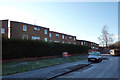
Hardy Farm Residence, Hardy Lane, Chorlton
The Hardy Farm hall of residence was built by UMIST in the very early 1970s adjacent to their Hardy Farm Sports Ground. The sports pitches were ultimately abandoned due to subsidence, but the student accommodation remains. As of February 2012 a room in an 8 bed house costs £325 a month.
Image: © Phil Champion
Taken: 18 Dec 2011
0.00 miles
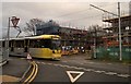
3

Tram lines leaving Hardy Lane, Chorlton-cum-Hardy
Image: © habiloid
Taken: 7 Aug 2023
0.01 miles
4
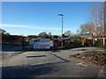
A rash of signs at Hardy Farm, Chorlton
This is the view from the very end of Hardy Lane, at the entrance to Hardy Farm. The extension of the Metrolink tram network towards Manchester Airport will be routed down Hardy Lane and a site compound had already been constructed just beyond the former pavilion building. Most of the signs seen here relate to the construction project.
In the late 1960s or early 70s UMIST reclaimed low lying land alongside the river Mersey and created the Hardy Farm Sports Ground. The pavilion can just be seen peeking out above the fencing. However later subsidence caused the sports pitches to be abandoned. The University later sold much of the land to West Didsbury and Chorlton Grounds Ltd who applied for permission to develop the site, creating a number of grass and astroturf pitches, with associated floodlighting etc. This application was withdrawn. In early 2011 Christian organisation Betel of Britain gained planning consent to convert the pavilion to a residential training centre. They have also announced plans for the management of the rest of the Upper Hardy Farm site which, whilst involving restoration of the playing fields, appears to be rather more sensitive and take into account the biological importance of the site and allow for continued informal public access.
Image: © Phil Champion
Taken: 18 Dec 2011
0.02 miles
5
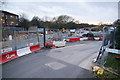
Metrolink construction at the end of Hardy Lane
This will be the route of the new line to Manchester Airport. The road originally ended here, and a new bridge has been built to cross the Mersey.
Image: © Bill Boaden
Taken: 7 Dec 2013
0.02 miles
6
Hardy Lane
The #84 bus from Withington Hospital does a three-point-turn near the end of Hardy Lane. Photograph taken through the side window.
Image: © Gerald England
Taken: 22 Apr 2010
0.02 miles
7
South west end of Hardy lane, looking in the direction of Barlow Moor Road
When Hardy Lane was widened from a narrow country lane in the 1920s, the planners had in mind an extension across the Mersey to form a significant arterial road. This explains the exceptional width of what is essentially a cul-de-sac. (The Hardy Lane Extension was still being seriously considered into the late 1960s / early 1970s when the M63 was being designed and built, with junctions set out with this link in mind).
This view is set to change substantially in coming years as the Metrolink line to the airport is due to be constructed along this road, continuing towards a river crossing near Jackson's Boat.
Image: © Phil Champion
Taken: 18 Dec 2011
0.02 miles
8
1930s houses at the end of Hardy Lane, Chorlton
These private houses were built sometime in the late 1930s. They are the very last houses on Hardy Lane. Prior to the 1920 Hardy Lane was a quiet rural lane leading to Hardy Farm and a handful of cottages on the edge of the floodplain of the Mersey. The road was substantially widened when Manchester Corporation built houses in the area in the 1920s/ 30s, with a small area of speculative private development near Hardy Farm.
Hardy Lane is unusually wide, although at the Hardy Farm end the carriageway narrows, with a large area of verge in front this last block of houses. The planners had in mind a future extension across the river to Sale in mind, to form a significant arterial road. When the M63 Sale Eastern Bypass was being designed and constructed in the 1960s proposals were in place for a new link road, to be carried across the low lying land at Hardy Farm on a 20ft high embankment. This was never built, although the motorway junction (now M60 J6) was built with this in mind.
Although spare from thundering traffic passing their front doors, these houses will in future have the frequent swish of trams, as the Metrolink line to Manchester Airport will run along Hardy Lane - the barriers seen here relate to works to move utilities in advance of the start of construction proper.
Image: © Phil Champion
Taken: 18 Dec 2011
0.05 miles
9
Hardy Lane - Mission Failure
Hardy Lane's width gives a clue to the original intent to create a dual carriageway link through to Sale, across the River Mersey and originally in a different county. All the M63 (now M60) junctions were built on that assumption, hence today's impossibility of exiting the M60 northwards from the west and the pain of getting across the Mersey from Sale Moor.
Image: © Peter Whatley
Taken: 1 Apr 2009
0.05 miles
10
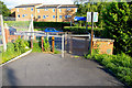
Cycle path at Hardy Farm, Hardy Lane
The buildings are part of the Hardy Farm Halls of Residence. Hardy Lane runs to the left, beyond the barrier. From here a path runs across Hardy Farm to the river Mersey and Trans Pennine Trail at Jackson's Boat.
Image: © Phil Champion
Taken: 25 May 2007
0.07 miles