IMAGES TAKEN NEAR TO
Adelaide Street, LUTON, LU1 5BB
Introduction
This page details the photographs taken nearby to Adelaide Street, LU1 5BB by members of the Geograph project.
The Geograph project started in 2005 with the aim of publishing, organising and preserving representative images for every square kilometre of Great Britain, Ireland and the Isle of Man.

There are currently over 7.5m images from over14,400 individuals and you can help contribute to the project by visiting https://www.geograph.org.uk
Image Map
Images are licensed for reuse under creativecommons.org/licenses/by-sa/2.0
Notes
- Clicking on the map will re-center to the selected point.
- The higher the marker number, the further away the image location is from the centre of the postcode.
Image Listing (116 Images Found)
Images are licensed for reuse under creativecommons.org/licenses/by-sa/2.0
Image
Details
Distance
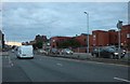
1

Luton from the air
Looking north just after take-off from the airport. The A505 passing round the town centre and the Midland Line railway can just be made out.
Image: © M J Richardson
Taken: 29 Jun 2015
0.04 miles
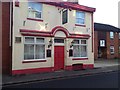
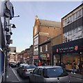
2
Stuart Street, Luton
The magistrates court is on the right
Image: © David Howard
Taken: 6 Sep 2020
0.06 miles
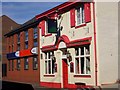
6
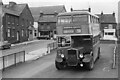
Regent Street, Luton ? 1972
United Counties bus 945 stands in the small bus terminus area on Regent Street. The stand itself is now a car park, but all the buildings in the view have been swept away and replaced by modern commercial development.
Bus 945 is a Bristol KSW with ECW body, the last of its type to enter service with the company, in 1954, and at 18 years of age is well beyond the average life expectancy of a bus of that period.
This is one of a series of views featuring buses in the 60s, 70s, and 80s. http://www.geograph.org.uk/search.php?i=137652761
Image: © Alan Murray-Rust
Taken: 8 Apr 1972
0.08 miles
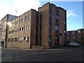
9
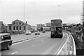
Chapel Viaduct, Luton ? 1972
Fairly newly constructed as part of Luton's inner ring, it took its name from the Baptist Chapel, since demolished.
United Counties bus 945 is about to turn into the small bus stand at Regent Street, just behind the photographer, now a car park. It is a Bristol KSW with ECW body, the last of its type to enter service with the company, in 1954, and at 18 years of age is well beyond the average life expectancy of a bus of that period.
This is one of a series of views featuring buses in the 60s, 70s, and 80s. http://www.geograph.org.uk/search.php?i=137652761
Image: © Alan Murray-Rust
Taken: 8 Apr 1972
0.11 miles
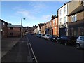
10
Northwest and downhill on Wellington Street, Luton
In a street of restaurants and fast food outlets, this four-storey building stands out. The datestone on the gable says 1906. While it might have been a hatmaker's (hatmaking was a major industry in Luton) it looks more like a former furniture showroom. It is seen square-on in Burgess von Thunen's Image from 2013. In this photo, note the large Salvation Army charity shop on the right.
Image: © Robin Stott
Taken: 24 Feb 2017
0.13 miles