IMAGES TAKEN NEAR TO
Leeds Road, OTLEY, LS21 3BR
Introduction
This page details the photographs taken nearby to Leeds Road, LS21 3BR by members of the Geograph project.
The Geograph project started in 2005 with the aim of publishing, organising and preserving representative images for every square kilometre of Great Britain, Ireland and the Isle of Man.

There are currently over 7.5m images from over14,400 individuals and you can help contribute to the project by visiting https://www.geograph.org.uk
Image Map
Images are licensed for reuse under creativecommons.org/licenses/by-sa/2.0
Notes
- Clicking on the map will re-center to the selected point.
- The higher the marker number, the further away the image location is from the centre of the postcode.
Image Listing (56 Images Found)
Images are licensed for reuse under creativecommons.org/licenses/by-sa/2.0
Image
Details
Distance
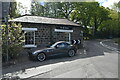
1
Bus shelter
A well-built stone bus shelter on Leeds Road near Pool Bank. An inscription inside says that it was
PRESENTED TO POOL PARISH COUNCIL
BY HOLMES WILLIAM WHITELEY
1955
Unfortunately the back window is boarded up, otherwise it would give a fine view over Wharfedale.
Image: © John Illingworth
Taken: 23 May 2012
0.03 miles
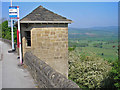
4
The Bar House
Grade II listed. https://historicengland.org.uk/listing/the-list/list-entry/1261141
Image: © N Chadwick
Taken: 4 May 2019
0.06 miles
5
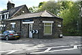
The Bar House
Grade II listed. https://historicengland.org.uk/listing/the-list/list-entry/1261141
Image: © N Chadwick
Taken: 4 May 2019
0.06 miles
6
Bar House, Pool Bank
Dating from c 1780, a former toll house on the Leeds to Skipton turnpike road, now the A660. Listed grade II (1261141). See Image for a view from a different angle.
Image: © Stephen Craven
Taken: 28 Dec 2020
0.06 miles
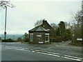
7
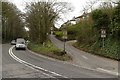
Former bridge supports on Leeds Road
There used to be a bridge here which carried the Pool Bank quarry tramway over the road. The support to the left of the photograph has been removed, probably to improve visibility at the junction with Old Pool Bank. The base of the support has survived and it is possible that a cut bench mark shown on old maps is under the earth bank with daffodils on it.
Image: © Mark Anderson
Taken: 20 Apr 2018
0.06 miles
8
Leeds Road junction with Old Pool Bank
The remains of an old bridge support for the Pool Bank quarry tramway can be seen in the middle of the photograph.
Image: © Mark Anderson
Taken: 20 Apr 2018
0.06 miles
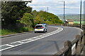
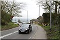
9
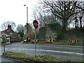
Stop sign at the bottom of Old Pool Bank
The 'stop' rather than 'give way' is because of the location at a blind bend on a busy main road. The stone structure across the main road is the remains of the abutment of a railway bridge that carried a tramway taking stone from Pool Bank Quarries to the Otley-Ilkley railway line. A full history of the quarries can be found at https://www.poolinwharfedalehistory.co.uk/6-pool-bank-quarries/ and gives the date of construction of the bridge as 1891 and its removal in 1941.
Image: © Stephen Craven
Taken: 28 Dec 2020
0.06 miles