IMAGES TAKEN NEAR TO
Scott Hall Road, LEEDS, LS17 6HH
Introduction
This page details the photographs taken nearby to Scott Hall Road, LS17 6HH by members of the Geograph project.
The Geograph project started in 2005 with the aim of publishing, organising and preserving representative images for every square kilometre of Great Britain, Ireland and the Isle of Man.

There are currently over 7.5m images from over14,400 individuals and you can help contribute to the project by visiting https://www.geograph.org.uk
Image Map
Images are licensed for reuse under creativecommons.org/licenses/by-sa/2.0
Notes
- Clicking on the map will re-center to the selected point.
- The higher the marker number, the further away the image location is from the centre of the postcode.
Image Listing (110 Images Found)
Images are licensed for reuse under creativecommons.org/licenses/by-sa/2.0
Image
Details
Distance
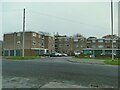
1
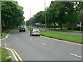
Scott Hall Road, Moortown, Leeds
Looking southwest from the roundabout at the junction with Harrogate Road.
Image: © Rich Tea
Taken: 7 Jun 2008
0.03 miles
2
This will be Belgravia
A couple of Victorian or Edwardian houses have been demolished along Harrogate Road at Moortown in Leeds, to make way for a development of apartments to be known as The Belgravia.
Image: © Rich Tea
Taken: 7 Jun 2008
0.03 miles
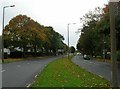
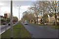
4
Harrogate Road, Moortown, Leeds
Looking north from a pedestrian refuge in the middle of the road.
Image: © Rich Tea
Taken: 7 Jun 2008
0.06 miles
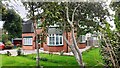
5
Moorfield (housing), Stonegate Road
The name comes from the farm that previously occupied the site. The flats are provided with a generous amount of parking, including both integral and separate garages.
Image: © Stephen Craven
Taken: 7 Nov 2020
0.06 miles
7
#389 Harrogate Road
Ordnance Survey documents indicate that a benchmark was levelled at 137.552m above Newlyn Datum on the near corner of the house in 1990
Image: © Roger Templeman
Taken: 24 Aug 2023
0.07 miles
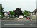
8
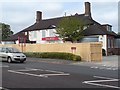
Farewell The Bull
The Bull was better known as The Chained Bull until fairly recently. This building replaced an older pub of the same name, next to a forge.
The pub closed sometime in the past 2 or 3 years, and is about to be demolished to make way for extra car parking for Marks and Spencer (behind it) which will also be extended.
This week, asbestos is being removed, and demolition will start next week.
See it in happier times Image] and a few weeks later Image]
See a picture of the earlier building in 1925 on Leodis http://www.leodis.net/display.aspx?resourceIdentifier=200273_10375613
Image: © Rich Tea
Taken: 13 May 2008
0.07 miles
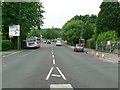
9
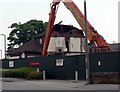
Mine was a pint
Three-quarters of The Chained Bull has now been demolished.
Image: © Rich Tea
Taken: 7 Jun 2008
0.07 miles
10
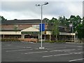
Marks & Spencer Simply Food, Moortown Corner
The store is decorated and has a window display celebrating their 125th Anniversary.
The section of the car park in the foreground was the site of The Chained Bull, which was demolished in 2008 to extend the car park. See Image]
Image: © Rich Tea
Taken: 28 May 2009
0.07 miles