IMAGES TAKEN NEAR TO
Station Road, LEEDS, LS15 4BT
Introduction
This page details the photographs taken nearby to Station Road, LS15 4BT by members of the Geograph project.
The Geograph project started in 2005 with the aim of publishing, organising and preserving representative images for every square kilometre of Great Britain, Ireland and the Isle of Man.

There are currently over 7.5m images from over14,400 individuals and you can help contribute to the project by visiting https://www.geograph.org.uk
Image Map (Loading...)


Getting Data...Please wait
Leaflet Map data © OpenStreetMap
Images are licensed for reuse under creativecommons.org/licenses/by-sa/2.0
Notes
- Clicking on the map will re-center to the selected point.
- The higher the marker number, the further away the image location is from the centre of the postcode.
Image Listing (57 Images Found)
Images are licensed for reuse under creativecommons.org/licenses/by-sa/2.0
Image
Details
Distance
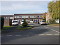
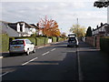
3
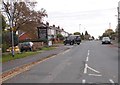
A walk from Oulton Church #51
Walking down Rakehill Road.
Image: © Ian S
Taken: 14 Aug 2010
0.03 miles
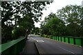
4
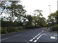
Former railway bridge at Scholes
The skew bridge carried Station Road over the Cross Gates to Wetherby railway line.
Image: © Stephen Craven
Taken: 14 Sep 2019
0.04 miles
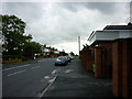
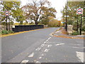
6
Bridge on Scholes Lane
The Cross Gates–Wetherby line would have passed under this bridge which is close to the former Scholes station. For more information on the former railway see: https://en.wikipedia.org/wiki/Cross_Gates%E2%80%93Wetherby_line and for information on the railway station see: https://en.wikipedia.org/wiki/Scholes_railway_station
Image: © DS Pugh
Taken: 3 Aug 2024
0.05 miles
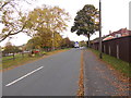
10
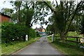
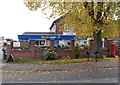
Road to the Buffers
The Buffers is a pub in the former Scholes Railway Station on the long dismantled Cross Gates–Wetherby line. For more information on the former railway see: https://en.wikipedia.org/wiki/Cross_Gates%E2%80%93Wetherby_line and for information on the railway station see: https://en.wikipedia.org/wiki/Scholes_railway_station
Image: © DS Pugh
Taken: 3 Aug 2024
0.05 miles