IMAGES TAKEN NEAR TO
LS12 2SJ
Introduction
This page details the photographs taken nearby to LS12 2SJ by members of the Geograph project.
The Geograph project started in 2005 with the aim of publishing, organising and preserving representative images for every square kilometre of Great Britain, Ireland and the Isle of Man.

There are currently over 7.5m images from over14,400 individuals and you can help contribute to the project by visiting https://www.geograph.org.uk
Image Map
Images are licensed for reuse under creativecommons.org/licenses/by-sa/2.0
Notes
- Clicking on the map will re-center to the selected point.
- The higher the marker number, the further away the image location is from the centre of the postcode.
Image Listing (310 Images Found)
Images are licensed for reuse under creativecommons.org/licenses/by-sa/2.0
Image
Details
Distance
1
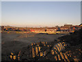
New development off Raynville Road
What puzzled me here was that the contractors had dug a deep trench right across the site and inserted a large precast concrete culvert (some spare sections of it can be seen in the background). I'm not aware of a stream running across the site - the orientation is along rather than down the slope - so the purpose is unclear.
Image: © Stephen Craven
Taken: 31 Mar 2018
0.01 miles
2
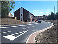
Hall Way
A new social housing development of 11 houses and 3 bungalows by Habinteg Housing, on the site of the former Wyther Park Community Centre, and opened in July 2018. Hall Way, named after Graham Hall Image, additionally links two existing roads, Raynville Road (this end) and Raynville Crescent, forming a convenient local short cut.
A deep concrete culvert runs beneath the road Image
Image: © Stephen Craven
Taken: 22 Jul 2018
0.01 miles
3
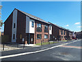
New houses on Hall Way
Part of a new social housing development of 11 houses and 3 bungalows by Habinteg Housing, on the site of the former Wyther Park Community Centre, and opened in July 2018.
Image: © Stephen Craven
Taken: 22 Jul 2018
0.01 miles
4
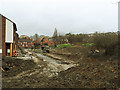
Demolition site, Raynville Road, Bramley
The site had previously been a community centre Image but had been cleared ready for new construction. According to the planning application (leeds.gov.uk ref. 16/00509) the proposal by Habinteg Housing Association is for "11 affordable houses and 3 affordable bungalows, with associated parking and landscaping".
Image: © Stephen Craven
Taken: 7 Apr 2017
0.02 miles
5
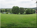
Site of former Wyther Park Community Centre
Viewed from the Houghley Gill footpath. A rectangular area within the Raynville Crescent Public Open Space, surrounded by metal fencing, and with evidence of previous floodlighting. I presumed it was a sports facility of some kind, but now disused and overgrown. However a subsequent planning application for housing on the site gave its previous use as the "Wyther Park Community Centre". Another document on Leeds Council website reveals that this was "used [from] 2006 until 2010 as a community hub for training and
activities [but] there is no longer a demand for this facility".
Image: © Stephen Craven
Taken: 2 Aug 2015
0.02 miles
6
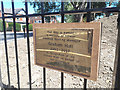
Plaque to Graham Hall
The plaque commemorates Graham Hall (1953-2017), who worked for Habinteg Housing which developed the adjacent houses Image
Image: © Stephen Craven
Taken: 22 Jul 2018
0.03 miles
7
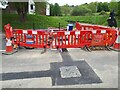
Fibre cable installation on Raynville Road
There have been temporary traffic lights on the road or several weeks as contractors install multiple purple cable ducts. Usually such ducts are laid in the footpath, but I guess that with multiple operators now having cable networks in city areas the footpaths have become congested and they now have to be laid in the road itself, with heavy duty covers on the drawpits.
Image: © Stephen Craven
Taken: 15 May 2022
0.03 miles
8
NEW
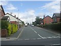
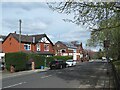
New speed remider on Raynville Road
This 30mph road has had a speeding problem for some time. A new display installed in April 2024 tells drivers their actual speed. But there is no enforcement with this system, and I expect those who deliberately overspeed will not be persuaded otherwise.
Image: © Stephen Craven
Taken: 21 Apr 2024
0.03 miles
9
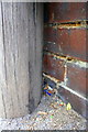
Benchmark behind BT pole on wall at junction of #20/#18 Raynville Road
Ordnance Survey cut mark benchmark described on the Bench Mark Database at www.bench-marks.org.uk/bm83925
Image: © Roger Templeman
Taken: 20 Apr 2017
0.03 miles