IMAGES TAKEN NEAR TO
Navigation Walk, LEEDS, LS10 1JH
Introduction
This page details the photographs taken nearby to Navigation Walk, LS10 1JH by members of the Geograph project.
The Geograph project started in 2005 with the aim of publishing, organising and preserving representative images for every square kilometre of Great Britain, Ireland and the Isle of Man.

There are currently over 7.5m images from over14,400 individuals and you can help contribute to the project by visiting https://www.geograph.org.uk
Image Map
Images are licensed for reuse under creativecommons.org/licenses/by-sa/2.0
Notes
- Clicking on the map will re-center to the selected point.
- The higher the marker number, the further away the image location is from the centre of the postcode.
Image Listing (1633 Images Found)
Images are licensed for reuse under creativecommons.org/licenses/by-sa/2.0
Image
Details
Distance
1
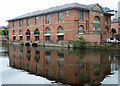
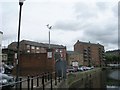
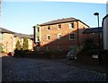
Flax House, Navigation Walk, Leeds
One of countless C19th warehouses converted into flats over the last few decades. This one dates perhaps from the middle of the century and has large arched windows and deep eaves.
Image: © Stephen Richards
Taken: 19 Jun 2011
0.01 miles
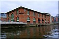
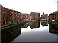
3
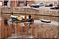
River Aire from Leeds Bridge
A variety of modifications of riverside warehouses into residential accommodation.
The tall building in the distance is 32/34 The Calls; dating from early 19th century, it was originally warehouse and mill, with access for barges at ground level. Listed Grade II.
Image: © Alan Murray-Rust
Taken: 11 Dec 2017
0.01 miles
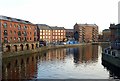
4
Calls Landing on the River Aire in Leeds
Looking east from Leeds Bridge.
The Calls was formerly an area of industry in Leeds along the banks of the River Aire. It is now regenerated with a mixture of offices, residential and leisure. In the distance is the tower of the Minster and Parish Church of Saint Peter-at-Leeds.
Image: © Mat Fascione
Taken: 4 Aug 2017
0.01 miles
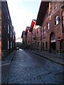
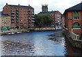
6
Navigation Walk
The bushes spell out "Victory Quay".
Image: © SMJ
Taken: 6 Dec 2008
0.02 miles