IMAGES TAKEN NEAR TO
South Street, HORNCASTLE, LN9 6DS
Introduction
This page details the photographs taken nearby to South Street, LN9 6DS by members of the Geograph project.
The Geograph project started in 2005 with the aim of publishing, organising and preserving representative images for every square kilometre of Great Britain, Ireland and the Isle of Man.

There are currently over 7.5m images from over14,400 individuals and you can help contribute to the project by visiting https://www.geograph.org.uk
Image Map
Images are licensed for reuse under creativecommons.org/licenses/by-sa/2.0
Notes
- Clicking on the map will re-center to the selected point.
- The higher the marker number, the further away the image location is from the centre of the postcode.
Image Listing (722 Images Found)
Images are licensed for reuse under creativecommons.org/licenses/by-sa/2.0
Image
Details
Distance
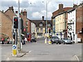
1
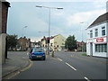
A158, Horncastle
At the lights, running from left to right, is the Lincoln to Skegness road.
Image: © Dave Hitchborne
Taken: 18 Jul 2009
0.01 miles
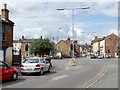
2
A158, Horncastle
Looking from South Street to the busy Lincoln to Skegness road, which runs from left to right. Three of Horncastle's ten pubs, that I know of, are in view. The white fronted building is The Ship with the Kings Head almost opposite. In the background, facing south, is The Red Lion.
Image: © Dave Hitchborne
Taken: 18 Jul 2009
0.01 miles
3
A158, Horncastle
The River Waring runs beneath here and has flooded in the past. On the 7th October 1960 it flooded to a height of 152.4cm when over 18.4cm of rain fell in 6 hours. The town has seen much flooding from both its rivers. In 1854, 1855, 1866, 1887, 1890, 1897, 1900, 1920, 1960, 1981, 1984, 2004 and 2007.
Image: © Dave Hitchborne
Taken: 18 Jul 2009
0.01 miles
4
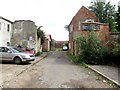
Hamerton Lane, Horncastle
H Ramsdale & Sons - Appears to be a working garage services.
Image: © Dave Hitchborne
Taken: 18 Jul 2009
0.02 miles
5
Hamerton Lane, Horncastle
H Ramsdale & Sons - Garage services. Inside, dogs were aware of my presence. Not sure who owns the Nissen hut.
Image: © Dave Hitchborne
Taken: 18 Jul 2009
0.02 miles
6

Hamerton Lane, Horncastle
H Ramsdale & Sons - The signage says that they are Motor Engineers and Auto Electricians. Expert servicing on diesel, petrol cars, commercial, agricultural and 4wd.
Image: © Dave Hitchborne
Taken: 18 Jul 2009
0.02 miles
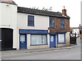
7
Ghost sign on former pub in Queen Street
The sign was advertising Batemans Ales and the building used to be The Cross Keys
Image: © Graham Hogg
Taken: 18 Aug 2014
0.02 miles
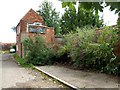
8
South Street, Horncastle
Nos.4 and 4a. 4a is listed as Garage Services. Two ornate gate posts at the entrance, but no gates.
Image: © Dave Hitchborne
Taken: 18 Jul 2009
0.02 miles
9
Horncastle cross roads
From A15 looking north
Image: © John Firth
Taken: 10 Jul 2011
0.02 miles
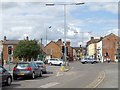
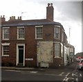
10
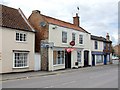
South Street, Horncastle
At No.6 is Harpers Bar pub, which sells keg beer, as I'm led to believe. To the left at Nos.8-12 is The Street Lamp - FH Manning Financial Services. To the right are what appear to be two private dwellings at No.s 4 and 4a, but No.4a is listed as Garage Services. Beyond is the A158 Lincoln to Skegness road and North Street, under which runs the River Waring. North Street is the A153 to Louth. South Street is the A153 to Sleaford, but heading south on the B1192, just east of Coningsby, will take you to Boston.
Image: © Dave Hitchborne
Taken: 18 Jul 2009
0.02 miles