IMAGES TAKEN NEAR TO
Sling, Tregarth, BANGOR, LL57 4RN
Introduction
This page details the photographs taken nearby to LL57 4RN by members of the Geograph project.
The Geograph project started in 2005 with the aim of publishing, organising and preserving representative images for every square kilometre of Great Britain, Ireland and the Isle of Man.

There are currently over 7.5m images from over14,400 individuals and you can help contribute to the project by visiting https://www.geograph.org.uk
Image Map
Images are licensed for reuse under creativecommons.org/licenses/by-sa/2.0
Notes
- Clicking on the map will re-center to the selected point.
- The higher the marker number, the further away the image location is from the centre of the postcode.
Image Listing (30 Images Found)
Images are licensed for reuse under creativecommons.org/licenses/by-sa/2.0
Image
Details
Distance
1
Gyfing and Bod Feurig cottages seen across the school yard
Image: © Eric Jones
Taken: 31 May 2008
0.02 miles
2
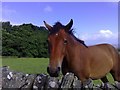
Friendly horse
A friendly horse looks over a dry stone wall along the lane leading to the former village school at Sling. In the far distance is Anglesey.
Image: © mick finn
Taken: 10 Aug 2008
0.02 miles
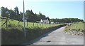
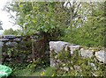
3
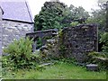
Remains of former village school, Sling
Adjoining the former schoolmaster's house, the gateway and walls were part of the former village school. At the other side of the driveway, to the right of the wall, the land falls sharply away but with a public footpath to the road below leading to Sling.
Image: © mick finn
Taken: 8 Aug 2008
0.02 miles
4
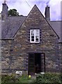
The schoolmaster's house at Sling, Gwynedd
Llain-y-ffynnon (translates, so I'm told, as 'place near a well' or 'place to prosper'. Suggestions welcome). It is the old schoolmaster's house, which stands on the hills above Sling, with magnificent views of Penrhyn Castle, the Menai Strait and Puffin Island below. The old school is a ruin, forming part of the garden.
Image: © mick finn
Taken: 8 Aug 2008
0.02 miles
5
Narrow Lane, Sling
A narrow, walled lane at Sling, Gwynedd. The village school is at the bottom to the left.
Image: © mick finn
Taken: 29 Nov 2008
0.04 miles
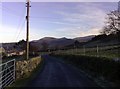
6
The Mynydd Llandygai road below Bryniau Eithinog
This is the main Deiniolen to Bethesda road. The road on the right leads to Sling.
Image: © Eric Jones
Taken: 31 May 2008
0.05 miles
7
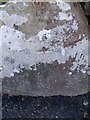
Benchmark on wall opposite Ysgol Bodfeurig, Sling
This benchmark is located on the SW side of the road opposite Ysgol Bodfeurig in Sling & it is shown in the current Ordnance Survey database at a height of 227.8746m above the Newlyn datum.
Image: © Meirion
Taken: 8 Apr 2011
0.05 miles
8
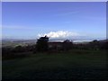
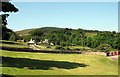
View from Sling
Penrhyn Castle and Anglesey are in the distance. Closer to home on the right is a lonely set of goalposts near the School.
Image: © mick finn
Taken: 29 Nov 2008
0.06 miles
9

Driveway at Sling
Driveway at the old school, Sling.
Image: © mick finn
Taken: 2 May 2009
0.07 miles
10
Iron Gate near Sling
Iron gate on a public footpath at the old school, Sling. The path descends steeply through the woods to the road below.
Image: © mick finn
Taken: 2 May 2009
0.07 miles