IMAGES TAKEN NEAR TO
Upper Llandwrog, CAERNARFON, LL54 7RE
Introduction
This page details the photographs taken nearby to LL54 7RE by members of the Geograph project.
The Geograph project started in 2005 with the aim of publishing, organising and preserving representative images for every square kilometre of Great Britain, Ireland and the Isle of Man.

There are currently over 7.5m images from over14,400 individuals and you can help contribute to the project by visiting https://www.geograph.org.uk
Image Map (Loading...)


Getting Data...Please wait
Leaflet Map data © OpenStreetMap
Images are licensed for reuse under creativecommons.org/licenses/by-sa/2.0
Notes
- Clicking on the map will re-center to the selected point.
- The higher the marker number, the further away the image location is from the centre of the postcode.
Image Listing (8 Images Found)
Images are licensed for reuse under creativecommons.org/licenses/by-sa/2.0
Image
Details
Distance
2
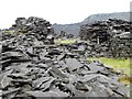
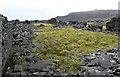
Slate piles, Braich quarry
Some of this may just be waste material, but some is definitely 'built' and may represent the ruins of old buildings. Such areas are fascinating, even when one has little idea about the history or layout of the place.
Image: © Gordon Hatton
Taken: 26 Sep 2017
0.13 miles
3
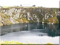
Flooded pit at Braich slate quarry
A large, and reputedly deep pool at the long abandoned Braich slate quarry above Y Fron. The date of the quarry hole is unknown, but is shown on the OS 6" map of 1888.
Image: © Gordon Hatton
Taken: 26 Sep 2017
0.18 miles
4
Ruined building at Braich quarry
This once large building is shown on 19thC OS maps, though unnamed. The map gives enough clues as to suggest that this was a large dressing area and that a tramway existed running from the far end of the building towards an incline to take the finished slates down towards the standard gauge line at the base of the hills.
Image: © Gordon Hatton
Taken: 26 Sep 2017
0.19 miles
5
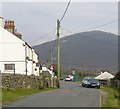
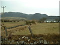
Y Fron village street
Y Fron is a linear village with houses lining this road and one other. The road here was once shared with a tramway carrying slate from nearby quarries, eventually meeting a railway line for transport to Caernarfon dock. There's a primary school here [hidden to the right of the parked cars], a bus service [note the green shelter], but I failed to see a shop. The background is dominated by the bulky shape of Mynydd Mawr.
Image: © Gordon Hatton
Taken: 26 Sep 2017
0.20 miles
6
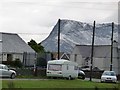
Roadside parking at Y Fron
The telegraph poles seem to measure the exact height of the mountain behind!
Image: © Christine Johnstone
Taken: 28 Nov 2009
0.22 miles
7
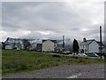
Open space at the village of Y Fron.
At about 300 metres above sea level, this is one of the highest villages for miles around.
Image: © Christine Johnstone
Taken: 28 Nov 2009
0.23 miles