IMAGES TAKEN NEAR TO
Treflys, PORTHMADOG, LL49 9YN
Introduction
This page details the photographs taken nearby to LL49 9YN by members of the Geograph project.
The Geograph project started in 2005 with the aim of publishing, organising and preserving representative images for every square kilometre of Great Britain, Ireland and the Isle of Man.

There are currently over 7.5m images from over14,400 individuals and you can help contribute to the project by visiting https://www.geograph.org.uk
Image Map
Images are licensed for reuse under creativecommons.org/licenses/by-sa/2.0
Notes
- Clicking on the map will re-center to the selected point.
- The higher the marker number, the further away the image location is from the centre of the postcode.
Image Listing (15 Images Found)
Images are licensed for reuse under creativecommons.org/licenses/by-sa/2.0
Image
Details
Distance
1
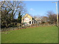
Former chapel
In the process of being converted into a residence.
Image: © Dewi
Taken: 17 Feb 2007
0.02 miles
2
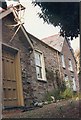
Brynmelyn chapel
The door to the chapel and the chapel house c1985. The site was surrounded by trees and it was not possible to get a wider view.
Image: © Dewi
Taken: Unknown
0.02 miles
3
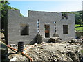
A chapel no more.....
The old Brynmelyn chapel [See http://www.geograph.org.uk/photo/343081] has completely gone and replacement is well under way.
Image: © David Medcalf
Taken: 22 Aug 2007
0.03 miles
5
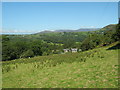
Farmland near Cefn Cyfanedd
Cefn Cyfannedd is the farm near the centre of the photo.
Image: © David Medcalf
Taken: 22 Aug 2007
0.11 miles
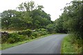
6
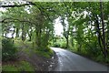
Road leading to Blackrock Sands
The road links the A497 to Blackrock Sands.
Image: © DS Pugh
Taken: 2 Aug 2018
0.12 miles
7
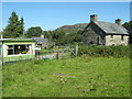
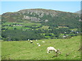
Farm below Moel-y-Gest
I didn't find the name of this farm, which is on the quieter north western side of the hill.
Image: © Bill Boaden
Taken: 25 Mar 2012
0.13 miles
8
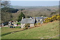
Farmland near Cefn Cyfanedd
Looking towards Craig y Gesail. Penmorfa village is just visible on the centre right.
Image: © David Medcalf
Taken: 22 Aug 2007
0.18 miles
9
Towards the A497
This road links Blackrock Sands to the A497.
Image: © DS Pugh
Taken: 2 Aug 2018
0.18 miles
10
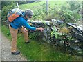
An OS Benchmark on the wall beside the track from Wern to Bron-y-foel
Image: © David Medcalf
Taken: 2 Aug 2020
0.20 miles