IMAGES TAKEN NEAR TO
Islawrdref, DOLGELLAU, LL40 1TW
Introduction
This page details the photographs taken nearby to LL40 1TW by members of the Geograph project.
The Geograph project started in 2005 with the aim of publishing, organising and preserving representative images for every square kilometre of Great Britain, Ireland and the Isle of Man.

There are currently over 7.5m images from over14,400 individuals and you can help contribute to the project by visiting https://www.geograph.org.uk
Image Map
Images are licensed for reuse under creativecommons.org/licenses/by-sa/2.0
Notes
- Clicking on the map will re-center to the selected point.
- The higher the marker number, the further away the image location is from the centre of the postcode.
Image Listing (9 Images Found)
Images are licensed for reuse under creativecommons.org/licenses/by-sa/2.0
Image
Details
Distance
1
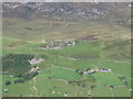
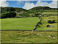
Nant y Gwyrddail
View from Tyrrau Mawr.
Image: © Chris Andrews
Taken: 23 Aug 2011
0.02 miles
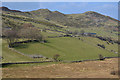
2
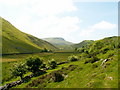
Farmland at Nant-y-gwyrddail
Ascending a farm path heading westwards towards the Cregennen Lakes in the valley below Cadair Idris
Image: © Keith Havercroft
Taken: 31 May 2006
0.12 miles
4
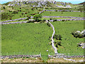
Wavy wall
Seen to good effect from Ffordd Ddu.
Image: © John Lucas
Taken: 26 May 2017
0.13 miles
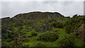
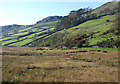
6
Fields near Nant-y-gwyrddail farm
Improved grazing on the slopes, marshy stuff on the valley floor.
Image: © Nigel Brown
Taken: 18 Mar 2015
0.14 miles
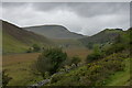
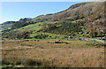
7
Marshland near Nant-y-gwyrddail
In contrast to the hillside, the very flat floor of the valley is very marshy; it has the look of a silted up llyn.
Image: © Nigel Brown
Taken: 3 Nov 2008
0.19 miles
8
Valley near Nant-y-gwyrddail
Not a lot of changes over the last nine years according to Image: The grass was greener and the sky was bluer.
Image: © Hansjoerg Lipp
Taken: 6 Oct 2015
0.23 miles
9
Hillside near Nant-y-gwyrddail
Good mixture of fields, mixed woodland, gorse and rock.
Image: © Nigel Brown
Taken: 3 Nov 2008
0.25 miles