IMAGES TAKEN NEAR TO
Bryncrug, TYWYN, LL36 9LF
Introduction
This page details the photographs taken nearby to LL36 9LF by members of the Geograph project.
The Geograph project started in 2005 with the aim of publishing, organising and preserving representative images for every square kilometre of Great Britain, Ireland and the Isle of Man.

There are currently over 7.5m images from over14,400 individuals and you can help contribute to the project by visiting https://www.geograph.org.uk
Image Map (17 Images)


Getting Data...Please wait
Leaflet Map data © OpenStreetMap
Images are licensed for reuse under creativecommons.org/licenses/by-sa/2.0
Notes
- Clicking on the map will re-center to the selected point.
- The higher the marker number, the further away the image location is from the centre of the postcode.
Image Listing (17 Images Found)
Images are licensed for reuse under creativecommons.org/licenses/by-sa/2.0
Image
Details
Distance
1
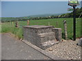
Dairy roadside churn stand
This churn stand is a relatively modern brick built structure standing as a monument to times past, the modern B&B sign next to it indicates the changes to the farm in recent years. There also appears to be suckler rather than dairy cows in the fields. Image]
Image: © John Haynes
Taken: 25 May 2012
0.01 miles
2
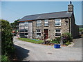
Extension at Pen-y-sarn farmhouse
This stone built farmhouse is being extended in thermalite blocks, I will be back to see how it is finished. Image]
Image: © John Haynes
Taken: 25 May 2012
0.02 miles
3
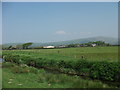
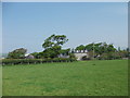
Pen-y-sarn a Tyn-yr-eithin fferm
A small farm this side of the A493 and the larger farm across the road.
Image]
Image]
As my view from the sea wall is higher than the former marshland it provides very good views.
Image: © John Haynes
Taken: 25 May 2012
0.04 miles
4
Tyn-yr-eithin fferm
This farm has diversified into a four star bed and breakfast provider. Image]
Image: © John Haynes
Taken: 25 May 2012
0.06 miles
5
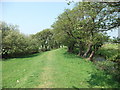
Nant Rhyd-yr-onen
This burn would have flowed out across the marshland to the sea before man intervened. Once the sea wall and the drains were constructed the water coming down the burn had to go straight to the river as it does today. Image]
Image: © John Haynes
Taken: 25 May 2012
0.16 miles
6
Bryncrug sewage works
A modern full treatment plant that discharges the effluent into Nant Rhyd-yr-onen to begin the journey to the sea. Image]
Image: © John Haynes
Taken: 25 May 2012
0.18 miles
7
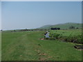
Llweybr Arfordir Cymru ar y morglawdd
This is the start of 2km on the top of the sea wall for the Wales Coast Path, magic walking for me.
http://www.ccw.gov.uk/enjoying-the-country/wales-coast-path.aspx?lang=en
http://www.ccgc.gov.uk/enjoying-the-country/wales-coast-path.aspx?lang=cy-gb
Image: © John Haynes
Taken: 25 May 2012
0.19 miles
8
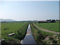
Main drain heading towards the sea
This drain takes water from a large area of marshland producing high quality improved grassland.
Image]
Image]
The modern farm buildings on the right are nameless.
Image: © John Haynes
Taken: 25 May 2012
0.20 miles
9
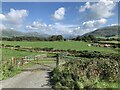
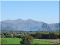
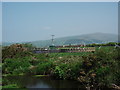
View from A493 across the Dysynni Valley (2)
Almost at the junction of two drainage ditches.
Image: © Richard Hoare
Taken: 15 Sep 2021
0.20 miles