IMAGES TAKEN NEAR TO
Eryl Place, LLANDUDNO, LL30 2TX
Introduction
This page details the photographs taken nearby to Eryl Place, LL30 2TX by members of the Geograph project.
The Geograph project started in 2005 with the aim of publishing, organising and preserving representative images for every square kilometre of Great Britain, Ireland and the Isle of Man.

There are currently over 7.5m images from over14,400 individuals and you can help contribute to the project by visiting https://www.geograph.org.uk
Image Map
Images are licensed for reuse under creativecommons.org/licenses/by-sa/2.0
Notes
- Clicking on the map will re-center to the selected point.
- The higher the marker number, the further away the image location is from the centre of the postcode.
Image Listing (64 Images Found)
Images are licensed for reuse under creativecommons.org/licenses/by-sa/2.0
Image
Details
Distance
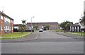
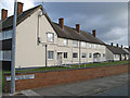
2
Denness Place, Llandudno
The houses here, leading off Trinity Avenue, are characteristic of local authority developments in the years immediately after the Second World War. They were in fact built in 1947 by Llandudno Urban District Council (UDC) in order to relieve what had become an acute housing shortage in the town. During the war a number of government departments had relocated from London to the area, which was seen as a safe haven from enemy bombing, thus boosting the local population. As servicemen returned from the forces after hostilities were ended there was an urgent need for new houses and Denness Place was one of a number of similar projects. Today many of the houses are privately owned.
Image: © Stephen McKay
Taken: 4 Oct 2024
0.05 miles
3
Llys Seiriol 1
A sheltered housing complex, built in the late 1960s but now no longer deemed fit for purpose, is boarded up prior to demolition and re-development. Work is expected to start in the late Winter for completion in 2015. The road in the foreground is Trinity Avenue.
Image: © Jonathan Wilkins
Taken: 23 Jan 2014
0.06 miles
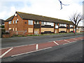
4
Llys Seiriol 2
A sheltered housing complex, built in the late 1960s but now no longer deemed fit for purpose, is boarded up prior to demolition and re-development. Work is expected to start in the late Winter for completion in 2015. This view is from the communal entrance on St.Andrews Road.
Image: © Jonathan Wilkins
Taken: 23 Jan 2014
0.06 miles
5
Recreation Ground by The Oval
The Oval is the home ground of Llandudno Cricket Club http://llandudno.play-cricket.com/ who play in the North Wales Premier Cricket League. The oldest recorded match at the ground was between Llandudno Visitors and Riviere's Orchestra on 12th August 1890 http://www.cricketarchive.com/Archive/Scorecards/293/293568.html
It is also home to the Llandudno Oval Bowling Club http://llandudnoovalbowlingclub.co.uk/ which was established in 1906.
The site includes a recreational area where football is played and during the summer car boot sales take place at the ground.
Image: © Gerald England
Taken: 15 Sep 2015
0.06 miles
6
Cysgod y Gogarth
Cartrefi Conwy’s £4M+ flagship, state-of-the-art, eco-friendly development promotes and supports independent living for older people. Cysgod y Gogarth replaced two ageing sheltered housing schemes in Llandudno consisting of 30 flats and bedsits at Llys Seiriol and the adjoining Llys Eryl in St Andrew’s Avenue, because they were not fit for purpose and did not address the local housing need.
Cysgod y Gogarth is the first new Independent Living scheme that Cartrefi Conwy has developed.
For views of Llys Seriol please see Image
Image: © Jonathan Wilkins
Taken: 6 Apr 2020
0.06 miles
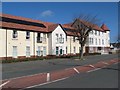
7
St.Andrews Road 1
A flats complex on St.Andrews Road.
Image: © Jonathan Wilkins
Taken: 23 Jan 2014
0.07 miles
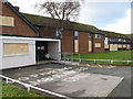
8
St.Andrews Road 2
Flats and bungalows set back from St.Andrews Road, looking towards the junction with Trinity Avenue.
Image: © Jonathan Wilkins
Taken: 23 Jan 2014
0.07 miles
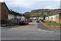
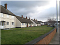
9
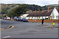
St Andrew's Avenue, Llandudno
St Andrew's Avenue is seen here from its junction with Trinity Avenue in the Llandudno suburbs; the Great Orme forms the backdrop. The terrace of bungalows was probably built in the 1950s for elderly people.
Image: © Stephen McKay
Taken: 4 Oct 2024
0.07 miles
10
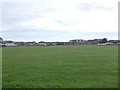
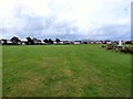
Playing Field - St Andrew's Avenue
Image: © Betty Longbottom
Taken: 21 Jul 2012
0.07 miles