IMAGES TAKEN NEAR TO
Llys Y Gopa, ABERGELE, LL22 7JH
Introduction
This page details the photographs taken nearby to Llys Y Gopa, LL22 7JH by members of the Geograph project.
The Geograph project started in 2005 with the aim of publishing, organising and preserving representative images for every square kilometre of Great Britain, Ireland and the Isle of Man.

There are currently over 7.5m images from over14,400 individuals and you can help contribute to the project by visiting https://www.geograph.org.uk
Image Map
Images are licensed for reuse under creativecommons.org/licenses/by-sa/2.0
Notes
- Clicking on the map will re-center to the selected point.
- The higher the marker number, the further away the image location is from the centre of the postcode.
Image Listing (3 Images Found)
Images are licensed for reuse under creativecommons.org/licenses/by-sa/2.0
Image
Details
Distance
1
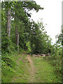
Woodland track
Small footpaths follow ledges on the hillside, many of them made for access to this once-commercial forestry. Now the area is access land and owned by Coed Cadw/Woodland Trust.
Image: © Jonathan Wilkins
Taken: 22 Aug 2008
0.20 miles
2
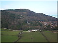
Castell Cawr
Castell Cawr, or locally Tan-y-Gopa, from Bryn Twr (Tower Hill) Abergele.
Castell Cawr is an iron-age hillfort. The hill is 189 metres high. There are caves with rare lesser-horseshoe bats in.
Image: © matt jones
Taken: 10 Feb 2014
0.21 miles
3
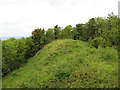
Castell Cawr
The forest has been cut back here to reveal the sizeable main rampart of the fine hill-fort that occupies this excellent defensive position on top of the cliff above Abergele. The main rampart secures the western side of the hilltop and there are many other ditches partly hidden in the trees.
Image: © Jonathan Wilkins
Taken: 22 Aug 2008
0.22 miles