IMAGES TAKEN NEAR TO
Nant Road, WREXHAM, LL11 3TH
Introduction
This page details the photographs taken nearby to Nant Road, LL11 3TH by members of the Geograph project.
The Geograph project started in 2005 with the aim of publishing, organising and preserving representative images for every square kilometre of Great Britain, Ireland and the Isle of Man.

There are currently over 7.5m images from over14,400 individuals and you can help contribute to the project by visiting https://www.geograph.org.uk
Image Map
Images are licensed for reuse under creativecommons.org/licenses/by-sa/2.0
Notes
- Clicking on the map will re-center to the selected point.
- The higher the marker number, the further away the image location is from the centre of the postcode.
Image Listing (8 Images Found)
Images are licensed for reuse under creativecommons.org/licenses/by-sa/2.0
Image
Details
Distance
1
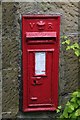
Late Post.
This Victorian Post Box, still in use today, although the collection time, 10.am. would appear to be earlier than the current delivery time!
Image: © Geoff Evans
Taken: 22 Jun 2007
0.05 miles
2
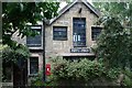
"Wheelers & Dealers."
This former shop has been altered into a private residence and now appears to be semi-derelict.Under the gable can be seen the pulley wheel used in the days when supplies where delivered and winched up to the warehouse over the shop where the long central window has replaced the door.
Image: © Geoff Evans
Taken: 22 Jun 2007
0.05 miles
3
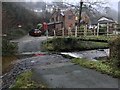
The Nant Ford
This is the second of the two fords on the River Clywedog at The Nant. A video of the ford can be seen at:
https://youtu.be/-I5v0xCiGzY
Image: © John Walton
Taken: 27 Dec 2019
0.09 miles
4
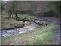
Bend in the River Clywedog
Just along the Clywedog Trail from Minera lead mines before Nant Mill
Image: © AntJB
Taken: 27 Jan 2008
0.10 miles
5
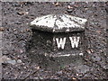
Mystery Cast Iron Marker
These markers are located on the Clywedog Trail, between Minera and Bersham. They are standing about 9''high, 9'' across, and marked W W.
They could be a boundary marker of the Williams-Wynn estate. Sir Watkin William Wynn held the Wynnstay estate near Ruabon. [information supplied by John Turner]
Image: © BrianPritchard
Taken: 14 Jul 2009
0.13 miles
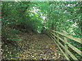
6
Stryt y Sgweiar
Between Coedpoeth and The Wern
Image: © Eirian Evans
Taken: 5 Oct 2017
0.14 miles
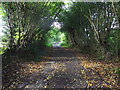
7
Clywedog Trail in Nant Woods
The Clywedog Valley Trail runs from Minera Lead Mines located around 5 miles to the west of Wrexham and finishes at King’s Mill approximately 1 mile to the south-east of the town centre. It is an easy to follow waymarked path along the river helping you to enjoy the natural beauty of this peaceful valley and uncover its rich history. The Clywedog Trail is approximately 5.5 miles from start to finish and can also be enjoyed in shorter sections.
Image: © Eirian Evans
Taken: 5 Oct 2017
0.15 miles
8
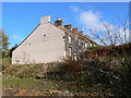
Row of terraces, Tudor Street, Coedpoeth
Image: © Eirian Evans
Taken: 6 Nov 2007
0.20 miles