IMAGES TAKEN NEAR TO
Repton Street, LEICESTER, LE3 5FD
Introduction
This page details the photographs taken nearby to Repton Street, LE3 5FD by members of the Geograph project.
The Geograph project started in 2005 with the aim of publishing, organising and preserving representative images for every square kilometre of Great Britain, Ireland and the Isle of Man.

There are currently over 7.5m images from over14,400 individuals and you can help contribute to the project by visiting https://www.geograph.org.uk
Image Map
Images are licensed for reuse under creativecommons.org/licenses/by-sa/2.0
Notes
- Clicking on the map will re-center to the selected point.
- The higher the marker number, the further away the image location is from the centre of the postcode.
Image Listing (222 Images Found)
Images are licensed for reuse under creativecommons.org/licenses/by-sa/2.0
Image
Details
Distance
1
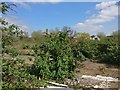
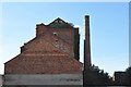
Wasteland at Frog Island
The site of a derelict factory next to Repton Street and the River Soar in the Frog Island area of Leicester.
Image: © Mat Fascione
Taken: 6 Apr 2017
0.02 miles
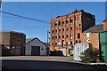
2
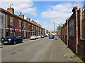
Repton Street at Frog Island, Leicester
Image: © Mat Fascione
Taken: 6 Apr 2017
0.02 miles
3
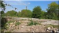
Wasteland at Frog Island
The site of a derelict factory next to Repton Street and the River Soar in the Frog Island area of Leicester.
Image: © Mat Fascione
Taken: 4 May 2017
0.03 miles
4
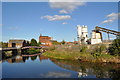
Industry on the Grand Union Canal
An old mill can be seen along with a bridge over a derelict spur of the canal. Some other more modern industry is to the right.
Image: © Ashley Dace
Taken: 17 Oct 2010
0.07 miles
6
Old Mill near Leicester Canal
An old mill, now unused and derelict.
Sadly due to fire part of the mill is to be demolished.
Image: © Ashley Dace
Taken: 17 Oct 2010
0.09 miles
7
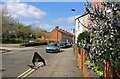
Bonchurch Street in Woodgate, Leicester
Image: © Mat Fascione
Taken: 6 Apr 2017
0.10 miles
8
Frog Island
Frog Island is the district sandwiched between the Grand Union Canal and the River Soar north west of Leicester city centre. The canalside buildings are rather run down, but the area is atmospheric.
Image: © Stephen McKay
Taken: 14 Oct 2007
0.10 miles
9

Bonchurch Street in Woodgate, Leicester
Image: © Mat Fascione
Taken: 4 May 2017
0.10 miles
10
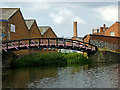
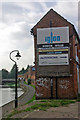
Canal arm on Frog Island in Leicester
The Grand Union Canal/Soar Navigation continues off to the right (north-east), two hundred metres to North Lock. This disused short arm and basin is on Frog Island beyond the purple towpath bridge. The canal here was engineered to improve the Soar Navigation flood management in the late nineteenth century.
Image: © Roger Kidd
Taken: 25 Aug 2013
0.10 miles