IMAGES TAKEN NEAR TO
The Slade Greens, LEICESTER, LE2 9AL
Introduction
This page details the photographs taken nearby to The Slade Greens, LE2 9AL by members of the Geograph project.
The Geograph project started in 2005 with the aim of publishing, organising and preserving representative images for every square kilometre of Great Britain, Ireland and the Isle of Man.

There are currently over 7.5m images from over14,400 individuals and you can help contribute to the project by visiting https://www.geograph.org.uk
Image Map
Images are licensed for reuse under creativecommons.org/licenses/by-sa/2.0
Notes
- Clicking on the map will re-center to the selected point.
- The higher the marker number, the further away the image location is from the centre of the postcode.
Image Listing (19 Images Found)
Images are licensed for reuse under creativecommons.org/licenses/by-sa/2.0
Image
Details
Distance
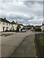
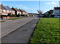
2
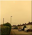
The Slade Greens in Eyres Monsell
The reddish sky was caused by the remnants of Hurricane Ophelia dragging in tropical air and dust from the Sahara, debris from forest fires in Portugal and Spain was also playing a part. The dust has caused shorter wavelength blue light to be scattered, making it appear red.
Image: © Mat Fascione
Taken: 16 Oct 2017
0.05 miles
3
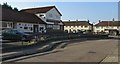
Scarlet Pimpernel in Eyres Monsell
A public house on Lawford Road.
Image: © Mat Fascione
Taken: 16 Oct 2017
0.10 miles
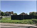
4
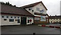
The Scarlet Pimpernel
Public house on the corner of Lawford Road and Howden Road, in the Eyres Monsell area of Leicester. The pub was currently closed down at the time this photo was taken.
Image: © Mat Fascione
Taken: 28 Feb 2020
0.10 miles
7
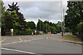
Lutterworth Road, Glen Parva
At the end of Gilmorton Road
Image: © David Howard
Taken: 2 Aug 2022
0.17 miles
8
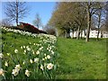
Daffodils along Glenhills Boulevard, Aylestone
Image: © Mat Fascione
Taken: 6 Apr 2017
0.18 miles
9
Red House Road in Eyres Monsell, Leicester
Image: © Mat Fascione
Taken: 20 Mar 2017
0.20 miles
10
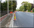
Constructing a pavement along Lutterworth Road
Part of the long running A426 Bus Corridor Project.
Image: © Mat Fascione
Taken: 27 Sep 2013
0.20 miles