IMAGES TAKEN NEAR TO
Great Arler Road, LEICESTER, LE2 6FF
Introduction
This page details the photographs taken nearby to Great Arler Road, LE2 6FF by members of the Geograph project.
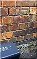
The Geograph project started in 2005 with the aim of publishing, organising and preserving representative images for every square kilometre of Great Britain, Ireland and the Isle of Man.

There are currently over 7.5m images from over14,400 individuals and you can help contribute to the project by visiting https://www.geograph.org.uk
Image Map
Images are licensed for reuse under creativecommons.org/licenses/by-sa/2.0
Notes
- Clicking on the map will re-center to the selected point.
- The higher the marker number, the further away the image location is from the centre of the postcode.
Image Listing (60 Images Found)
Images are licensed for reuse under creativecommons.org/licenses/by-sa/2.0
Image
Details
Distance
1
Benchmark on Co-op Funeral Care building, Welford Road
Ordnance Survey cut mark benchmark described on the Bench Mark Database at www.bench-marks.org.uk/bm88830
Image: © Roger Templeman
Taken: 13 Sep 2017
0.09 miles
2
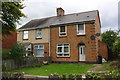
Nos. 360 and 362 Knighton Lane East
There is an Ordnance Survey benchmark Image on the side of the right hand house at its front corner beside the wheelie bin
Image: © Roger Templeman
Taken: 13 Sep 2017
0.09 miles
3
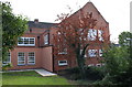
West wing of Sir Jonathan North Community College
Ordnance Survey documents indicate that in 1965 a benchmark levelled at 67.608m above Newlyn Datum was verified on the wall of the school to the left of the top of the steps. The mark is now hidden behind pink cladding.
Image: © Roger Templeman
Taken: 13 Sep 2017
0.09 miles
4
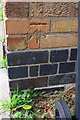
Benchmark on #362 Knighton Lane East
Ordnance Survey cut mark benchmark described on the Bench Mark Database at www.bench-marks.org.uk/bm88834
Image: © Roger Templeman
Taken: 13 Sep 2017
0.09 miles
5
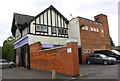
Co-op Funeral Care, Welford Road
There is an Ordnance Survey benchmark Image on the brick wall of the part of the building within the yard, left of the parked car and above a rat poison box. The tower of the building at the right hand end of the building has an Ordnance Survey triangulation station bolt on its roof, http://trigpointing.uk/trig/14277
Image: © Roger Templeman
Taken: 13 Sep 2017
0.09 miles
7
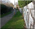
Alleyway to Knighton Lane East
Connecting with Pendlebury Drive.
Image: © Mat Fascione
Taken: 1 Mar 2009
0.12 miles
8
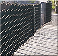
Fence next to Sir Jonathan North Community College
Image: © Mat Fascione
Taken: 2 Feb 2014
0.13 miles
9
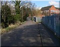
Footpath next to Sir Jonathan North Community College
Image: © Mat Fascione
Taken: 1 Mar 2009
0.15 miles