IMAGES TAKEN NEAR TO
Oxford Street, LEICESTER, LE1 5XQ
Introduction
This page details the photographs taken nearby to Oxford Street, LE1 5XQ by members of the Geograph project.
The Geograph project started in 2005 with the aim of publishing, organising and preserving representative images for every square kilometre of Great Britain, Ireland and the Isle of Man.

There are currently over 7.5m images from over14,400 individuals and you can help contribute to the project by visiting https://www.geograph.org.uk
Image Map
Images are licensed for reuse under creativecommons.org/licenses/by-sa/2.0
Notes
- Clicking on the map will re-center to the selected point.
- The higher the marker number, the further away the image location is from the centre of the postcode.
Image Listing (424 Images Found)
Images are licensed for reuse under creativecommons.org/licenses/by-sa/2.0
Image
Details
Distance
1
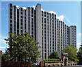
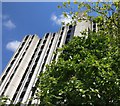
De Montfort House, Oxford Street, Leicester
A startling cliff-like edifice of concrete and glass, with jagged skyline and undulating elevations.
Flats, I think part of the De Montfort Housing Association's stable.
Closer view of the gateway in front: Image
Image: © Stephen Richards
Taken: 24 Aug 2011
0.00 miles
2
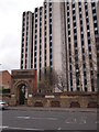
Leicester - LE1
A multi-storey block of flats on Oxford Street in the Southfields area - near to the Royal Infirmary - overshadows the remains of an old doorway or gateway leading into a communal open-space/turfed area.
Image: © David Hallam-Jones
Taken: 31 Mar 2012
0.02 miles
3
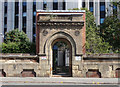
Former gateway, Oxford Street, Leicester
Originally the entrance to J.E. Pickard's Spinning Mill, built in the 1870s and demolished a century later.
It now stands before this building Image
Image: © Stephen Richards
Taken: 24 Aug 2011
0.02 miles
6
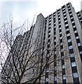
De Montfort House in Leicester
Located on Oxford Street, this 48 metre high block of flats is student accommodation, near The University of Leicester & De Montfort University.
Image: © Mat Fascione
Taken: 1 Mar 2015
0.03 miles
7
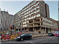
James House redevelopment
This building at 55 Welford Road is being demolished as part of a scheme which intends to replace it with 105 'build to rent' apartments, 350 student bedrooms, and commercial spaces on the ground floor.
Image: © Pierre Marshall
Taken: 20 Jan 2023
0.03 miles

9
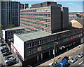
James House, Welford Road, Leicester
Large 1960s/1970s office block as seen from a multi-storey car park over the road.
Image: © Stephen Richards
Taken: 24 Aug 2011
0.05 miles
10
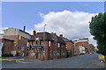
The Swan and Rushes, Leicester
After being empty for a year, the pub re-opened in 2018 with a modernised interior, but keeping the older, traditional facade. On its left, new student accommodation. Leicester architecture is a mixture of older, ugly 1960-70s high rise, and uninspiring modern buildings.
Image: © Tim Heaton
Taken: 13 Aug 2019
0.05 miles