IMAGES TAKEN NEAR TO
West Farm Drive, OAKHAM, LE15 8EU
Introduction
This page details the photographs taken nearby to West Farm Drive, LE15 8EU by members of the Geograph project.
The Geograph project started in 2005 with the aim of publishing, organising and preserving representative images for every square kilometre of Great Britain, Ireland and the Isle of Man.

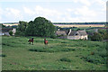
There are currently over 7.5m images from over14,400 individuals and you can help contribute to the project by visiting https://www.geograph.org.uk
Image Map
Images are licensed for reuse under creativecommons.org/licenses/by-sa/2.0
Notes
- Clicking on the map will re-center to the selected point.
- The higher the marker number, the further away the image location is from the centre of the postcode.
Image Listing (156 Images Found)
Images are licensed for reuse under creativecommons.org/licenses/by-sa/2.0
Image
Details
Distance
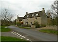
1
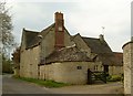
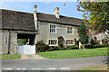
West Farmhouse, Barrowden
The house dates back to around 1700, with a couple of specific datestones for 1724 and 1883 which clearly indicate later additions. The 1724 date appears in the panel on the brick chimney stack. Basic structure is coursed stone rubble with Collyweston stone slate roof, Listed Grade II.
Image: © Alan Murray-Rust
Taken: 11 Apr 2016
0.02 miles
2
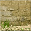
Bench mark, 29 Main Street, Barrowden
See http://www.geograph.org.uk/photo/4908973 for location.
Image: © Alan Murray-Rust
Taken: 11 Apr 2016
0.02 miles
3
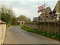
Main Street, Barrowden, the west end
Taken from by West Farmhouse entrance. There is a bench mark http://www.geograph.org.uk/photo/4908968 on the gable being rebuilt on the right.
Image: © Alan Murray-Rust
Taken: 11 Apr 2016
0.04 miles
4
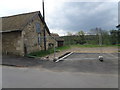
Farm yard in Barrowden
Pictured before developers change the local landscape with a housing development.
Image: © Michael Trolove
Taken: 1 May 2009
0.05 miles
5
Barrowden, Rutland
Looking south across the village from Back Road. The hill in the distance is in Image
Image: © Kate Jewell
Taken: 1 Sep 2006
0.05 miles
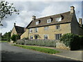
6
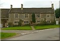
Durant Farmhouse, 27 Main Street, Barrowden
Late 16th or early 17th century Grade II* Listed house. The listing includes the barn partly in view to the left Image A John Durant who died in 1552 held land in Barrowden and his son Rowland died in 1588 and grandson George in 1594 any of whom could have been responsible for the house.
Image: © Jo and Steve Turner
Taken: 28 Aug 2017
0.07 miles
7
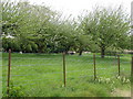
Orchard in Barrowden
A traditional orchard in the heart of village which is surprising.
Image: © Michael Trolove
Taken: 1 May 2009
0.07 miles
8
Durant Farmhouse. Barrowden
Probably the oldest secular building in the village, it is thought to be the house noted as owned by John Durant in 1552. It features coursed squared stone with alternating thin bands of ironstone, stone mullioned and transomed windows and Collyweston stone slate roof. Listed Grade II* complete with the attached barn http://www.geograph.org.uk/photo/4908965 to the left.
Image: © Alan Murray-Rust
Taken: 11 Apr 2016
0.07 miles
9
32,34 Main Street, Barrowden
Possibly originally a single house, dating from c.1700; coursed stone rubble with ashlar dressings and Collyweston stone slate roof, Listed Grade II.
Image: © Alan Murray-Rust
Taken: 11 Apr 2016
0.07 miles
10
32 and 34 Main Street, Barrowden
Date from about 1700 https://historicengland.org.uk/listing/the-list/list-entry/1307600?section=official-list-entry
Image: © Jonathan Thacker
Taken: 12 Aug 2021
0.07 miles