IMAGES TAKEN NEAR TO
Chapel Close, MELTON MOWBRAY, LE14 3HW
Introduction
This page details the photographs taken nearby to Chapel Close, LE14 3HW by members of the Geograph project.
The Geograph project started in 2005 with the aim of publishing, organising and preserving representative images for every square kilometre of Great Britain, Ireland and the Isle of Man.

There are currently over 7.5m images from over14,400 individuals and you can help contribute to the project by visiting https://www.geograph.org.uk
Image Map
Images are licensed for reuse under creativecommons.org/licenses/by-sa/2.0
Notes
- Clicking on the map will re-center to the selected point.
- The higher the marker number, the further away the image location is from the centre of the postcode.
Image Listing (61 Images Found)
Images are licensed for reuse under creativecommons.org/licenses/by-sa/2.0
Image
Details
Distance
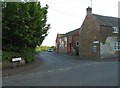
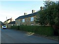
1
Former Methodist Sunday school and chapel
Currently undergoing conversion to a dwelling. Chapel built 1843 http://www.geograph.org.uk/photo/5209462 , extended 1877 at the far end; Sunday school at this end built 1898 http://www.geograph.org.uk/photo/5209466 .
Image: © Alan Murray-Rust
Taken: 25 Nov 2016
0.02 miles
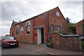
2
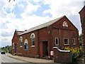
Wesleyan Chapel, Ab Kettleby
Founded 1845, with a Sunday School attached to the far end in 1898.
Image: © Tim Heaton
Taken: 30 Jul 2006
0.02 miles
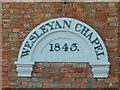
4
Wesleyan Chapel on Chapel Lane Ab Kettleby
Dated 1845.
Image: © Ian S
Taken: 31 Aug 2020
0.02 miles
5
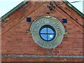
Sunday School roundel, 1898
See http://www.geograph.org.uk/photo/5209465 for location.
Image: © Alan Murray-Rust
Taken: 25 Nov 2016
0.03 miles
6
Datestone on the former Methodist chapel, Ab Kettleby
See http://www.geograph.org.uk/photo/212135 for location.
Image: © Alan Murray-Rust
Taken: 25 Nov 2016
0.03 miles
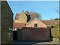
7
21 Wartnaby Road, Ab Kettleby
Former farmhouse, tentatively dated 1626 in the listing, the datestone being now too worn to be legible, with early 19th century extension at the far end. Listed Grade II.
Image: © Alan Murray-Rust
Taken: 25 Nov 2016
0.04 miles
8
The Manor House, Ab Kettleby
Early 17th century, possibly the oldest surviving building in the village apart from the church, but sited where there is no possibility of getting a decent view from a public viewpoint. Listed Grade II*.
Image: © Alan Murray-Rust
Taken: 25 Nov 2016
0.05 miles