IMAGES TAKEN NEAR TO
Woolton Park, LIVERPOOL, L25 6DT
Introduction
This page details the photographs taken nearby to Woolton Park, L25 6DT by members of the Geograph project.
The Geograph project started in 2005 with the aim of publishing, organising and preserving representative images for every square kilometre of Great Britain, Ireland and the Isle of Man.

There are currently over 7.5m images from over14,400 individuals and you can help contribute to the project by visiting https://www.geograph.org.uk
Image Map
Images are licensed for reuse under creativecommons.org/licenses/by-sa/2.0
Notes
- Clicking on the map will re-center to the selected point.
- The higher the marker number, the further away the image location is from the centre of the postcode.
Image Listing (25 Images Found)
Images are licensed for reuse under creativecommons.org/licenses/by-sa/2.0
Image
Details
Distance
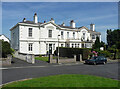
1
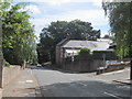
Woolton Hill Road
Woolton Hill Road was described in The Enclosure Act of 1805 as Red Brow, "40 ft wide, where hitherto the cows and sheep of Gateacre had drifted to their common pastures". Woolton Hill would have been common land of rough scrubland and red sandstone outcrops prior to becoming a favoured location for wealthy merchants to build grand country mansions. The house to the right is simply named "The Cottage" on early maps and is linked to the grand house Baycliff built in 1869-71 (now the residence of Liverpool's Anglican bishops known as Bishop's Lodge).
Image: © Sue Adair
Taken: 26 Aug 2016
0.05 miles
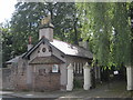
2
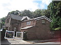
Cliff Cottage
Cliff Cottage and Woolton Hill Road lodge to Reynolds Park were part of the Dennison estate. The original two storey cottage was built at the beginning of the 19th century but much extended over the following seventy years or so. The Little Woolton Township Quarry lay between the back drive of Bishop's Lodge and Cliff Cottage, the area now called Parkwood Road. It is possible that the original cottage was connected to this stone quarry as the chimney has a flue which links to a stone chamber with fireplace 15ft below, which was most likely a quarryman's shelter. Between Cliff Cottage and Reynolds Park Lodge lies a further disused stone quarry.
Image: © Sue Adair
Taken: 26 Aug 2016
0.07 miles
3
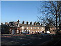
Old Cottages, Woolton Road
Grade II listed cottages at the junction of Cuckoo Lane with Woolton Road. The delightful corner cottage is like a gingerbread house with its architectural detailing, it was once a smithy and later a shop, it is now a nursery.
Image: © Sue Adair
Taken: 14 Feb 2007
0.08 miles
4
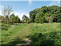
Reynolds Park, Liverpool
The area to the right of the path has been planted with wildflowers.
Image: © John Lord
Taken: 2 Jun 2021
0.09 miles
5
Reynolds Park Lodge
Originally the entrance lodge to the early 19th century Dennison's House which was situated adjacent to the deep stone quarry on Woolton Hill Road. Although the house was demolished in 1886 the driveway to the house continued to be known as 'Denison's Road' and lead to Dove Park, later to be renamed Reynold's Park http://www.geograph.org.uk/photo/386418.
Image: © Sue Adair
Taken: 26 Aug 2016
0.10 miles
6
Villas, Glenrose Road, Liverpool
Three stuccoed houses all joined together, Strawberry House, Mossdene and Crawfordsburn, built in the 1840s/1850s. Grade II listed.
Image: © Stephen Richards
Taken: 16 Aug 2016
0.16 miles
8
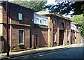
Former stables, Church Road, Liverpool
Formerly attached to Knolle Park and dating from the 1820s. Arched centrepiece, now flanked by "hideous" additions inexplicably permitted when the building was converted to housing. Grade II listed.
Image: © Stephen Richards
Taken: 16 Aug 2016
0.16 miles
9
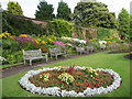
Floral Display in Reynolds Park Walled Garden
Image: © Sue Adair
Taken: 15 Aug 2007
0.17 miles
10
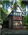
Lodge, Church Road, Liverpool
Half-timbered and tile-hung, dated 1888. It stands at the entrance to Reynolds Park (the house itself was destroyed by fire in the 1970s). Grade II listed.
Image: © Stephen Richards
Taken: 16 Aug 2016
0.17 miles