IMAGES TAKEN NEAR TO
Durham Terrace, LEVEN, KY8 6DS
Introduction
This page details the photographs taken nearby to Durham Terrace, KY8 6DS by members of the Geograph project.
The Geograph project started in 2005 with the aim of publishing, organising and preserving representative images for every square kilometre of Great Britain, Ireland and the Isle of Man.

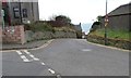
There are currently over 7.5m images from over14,400 individuals and you can help contribute to the project by visiting https://www.geograph.org.uk
Image Map
Images are licensed for reuse under creativecommons.org/licenses/by-sa/2.0
Notes
- Clicking on the map will re-center to the selected point.
- The higher the marker number, the further away the image location is from the centre of the postcode.
Image Listing (369 Images Found)
Images are licensed for reuse under creativecommons.org/licenses/by-sa/2.0
Image
Details
Distance
1
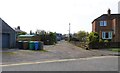
Durham Terrace, Lower Largo
Off Durham Wynd this road isn't a private road but why it isn't metalled is a mystery to me!
See Lower Largo article https://www.geograph.org.uk/article/Lower-Largo-and-the-Serpentine-Walk
Image: © Bill Kasman
Taken: 8 Apr 2019
0.02 miles
2
Fife Coastal Path
The Fife Coastal Path continues after leaving the rough car park in this image Image
See Lower Largo article https://www.geograph.org.uk/article/Lower-Largo-and-the-Serpentine-Walk
Image: © Bill Kasman
Taken: 29 Mar 2019
0.02 miles
3
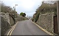
Durham Wynd, Lower Largo
The path from the rough car park in this image Image crosses Durham Wynd (at the first lamp post). This path can be considered as part of the Fife Coastal Path which follows the line of the old Fife Coast Railway.
See Lower Largo article https://www.geograph.org.uk/article/Lower-Largo-and-the-Serpentine-Walk
Image: © Bill Kasman
Taken: 29 Mar 2019
0.03 miles
4
Durham Wynd, Lower Largo
See Lower Largo article https://www.geograph.org.uk/article/Lower-Largo-and-the-Serpentine-Walk
Image: © Bill Kasman
Taken: 8 Apr 2019
0.03 miles
5
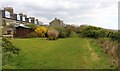
Road junction, Lower Largo
Bourtree Brae joins Durham Wynd which runs downhill to Main Street.
See Lower Largo article https://www.geograph.org.uk/article/Lower-Largo-and-the-Serpentine-Walk
Image: © Bill Kasman
Taken: 29 Mar 2019
0.04 miles
6
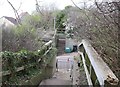
Fife Coastal Path
The path crosses Durham Wynd. Unlikely as it may seem this was the route of the former Fife Coast Railway. The handrail on the right seems to confirm this as it appears to be made from old railway sleepers.
See Lower Largo article https://www.geograph.org.uk/article/Lower-Largo-and-the-Serpentine-Walk
Image: © Bill Kasman
Taken: 29 Mar 2019
0.04 miles
7
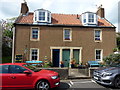
The Court House, 79 Main Street, Lower Largo
Built in the late 18th century, and Category B listed https://www.britishlistedbuildings.co.uk/200341176-lower-largo-79-main-street-court-house-leven-kennoway-and-largo-ward#.W2FeY1BKhPY in 1984.
Image: © Richard Law
Taken: 13 May 2018
0.04 miles
8
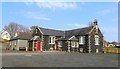
Durham Hall, Lower Largo
Originally built in the 1890s as a school Durham Hall was acquired by Largo St. David's Church in 1957 and now serves as a church and community hall.
See Lower Largo articlehttps://www.geograph.org.uk/article/Lower-Largo-and-the-Serpentine-Walk
Image: © Bill Kasman
Taken: 8 Apr 2019
0.04 miles
9
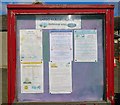
Notice Board
This notice board is at Durham Hall, Lower Largo Image
See Lower Largo articlehttps://www.geograph.org.uk/article/Lower-Largo-and-the-Serpentine-Walk
Image: © Bill Kasman
Taken: 9 Apr 2019
0.04 miles
10
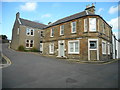
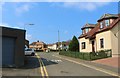
Corner of Main Street and Durham Wynd, Lower Largo
Image: © Richard Sutcliffe
Taken: 23 Mar 2019
0.05 miles