IMAGES TAKEN NEAR TO
Main Street, ST. ANDREWS, KY16 0UN
Introduction
This page details the photographs taken nearby to Main Street, KY16 0UN by members of the Geograph project.
The Geograph project started in 2005 with the aim of publishing, organising and preserving representative images for every square kilometre of Great Britain, Ireland and the Isle of Man.

There are currently over 7.5m images from over14,400 individuals and you can help contribute to the project by visiting https://www.geograph.org.uk
Image Map
Images are licensed for reuse under creativecommons.org/licenses/by-sa/2.0
Notes
- Clicking on the map will re-center to the selected point.
- The higher the marker number, the further away the image location is from the centre of the postcode.
Image Listing (65 Images Found)
Images are licensed for reuse under creativecommons.org/licenses/by-sa/2.0
Image
Details
Distance
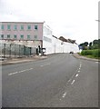
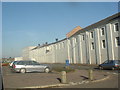
1
The A919 heading in to Guardbridge
In Fife.
Image: © James Denham
Taken: 2 Jun 2010
0.04 miles
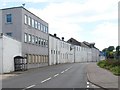
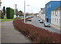
3
Paper Mill in Guardbridge
The clock is wrong by the way, at least most of the time.
Image: © Aleks Scholz
Taken: 9 Feb 2023
0.04 miles
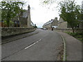
4
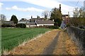
Seggie path
A short but nice path links the Innerbridge area of Guardbridge with Seggie Farm. Looking back down a section towards the mill.
Image: © Jim Bain
Taken: 19 Apr 2007
0.04 miles
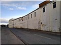
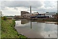
5
Paper Mill, Guardbridge
Whilst the mill is in this square, it may be that its carpark from which this shot is taken could be the next square west. The map seems to indicate the road (A919 St Andrews-Leuchars) divides the two.
Image: © Stanley Howe
Taken: 27 Oct 2005
0.07 miles
6
Guardbridge
Looking north along the line of the St Andrews branch line and the Leuchars road by the paper mill. The mill closed its doors for new orders in July 2008.
Image: © Jim Bain
Taken: 15 Feb 2008
0.07 miles
7
Innerbridge Street, Guardbridge
Looking south-westward.
Image: © Peter Wood
Taken: 9 May 2021
0.08 miles
8
Guardbridge Mill
looking across the Motray burn to the northern edge of the paper mill on the other side.
Image: © Jim Bain
Taken: 17 May 2006
0.08 miles
9
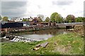
Weir on the Motray
Weir for the paper mill at Guardbridge with the A919 road bridge behind.
Image: © Jim Bain
Taken: 17 May 2006
0.08 miles
10
Guardbridge
The SE edge of Guardbridge from the Seggie path. The building on the right is Guardbridge Primary School.
Image: © Jim Bain
Taken: 19 Apr 2007
0.09 miles