IMAGES TAKEN NEAR TO
Boyle Farm Island, THAMES DITTON, KT7 0SJ
Introduction
This page details the photographs taken nearby to Boyle Farm Island, KT7 0SJ by members of the Geograph project.
The Geograph project started in 2005 with the aim of publishing, organising and preserving representative images for every square kilometre of Great Britain, Ireland and the Isle of Man.

There are currently over 7.5m images from over14,400 individuals and you can help contribute to the project by visiting https://www.geograph.org.uk
Image Map
Images are licensed for reuse under creativecommons.org/licenses/by-sa/2.0
Notes
- Clicking on the map will re-center to the selected point.
- The higher the marker number, the further away the image location is from the centre of the postcode.
Image Listing (176 Images Found)
Images are licensed for reuse under creativecommons.org/licenses/by-sa/2.0
Image
Details
Distance
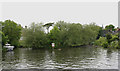
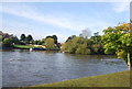
1
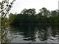
Boyle's Farm Island
Boyle Farm Island is the second largest of the three islands at Thames Ditton. It contains a single house, home to just one family. It is directly opposite the historic mansion of Boyle Farm. Whereas its larger partner, Thames Ditton Island, has at times been administratively part of Middlesex, Boyle Farm Island has always belonged to Surrey.
Image: © Eirian Evans
Taken: 13 Oct 2011
0.00 miles
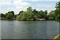
2
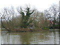
An island next to Thames Ditton Island
Seen from near the suspension bridge to Thames Ditton Island, this small island is a few yards downstream.
After the wettest winter on record and extensive flooding by the Thames the river was exceptionally high and fast-flowing. It seemed that many of the properties on the islands were flooded and on the mainland sandbags were to be seen everywhere.
Image: © Marathon
Taken: 19 Feb 2014
0.01 miles
3
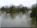
An island next to Thames Ditton Island
Seen from the suspension bridge to Thames Ditton Island, this small island is a few yards downstream.
After the wettest winter on record and extensive flooding by the Thames the river was exceptionally high and fast-flowing. It seemed that many of the properties on the islands were flooded and on the mainland sandbags were to be seen everywhere.
Image: © Marathon
Taken: 19 Feb 2014
0.01 miles
4
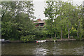
Boyle Farm Island
The island consists of a single dwelling hidden amongst trees.
Image: © David Kemp
Taken: 23 May 2009
0.01 miles
5
Swan Island
Swan Island is uninhabited and is situated between Boyle Farm Island (left) and Thames Ditton Island (right).
Image: © David Kemp
Taken: 23 May 2009
0.01 miles
7
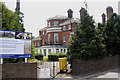
Home of Compassion, Thames Ditton
Work started on the construction of this house in the 1780s. It was known as Boyle Farm until 1905 when it was purchased by the Order of the Compassion of Jesus, an Anglican religious order. In due course it became the Home of Compassion, a charitable care facility for the elderly. As the sign suggests it is currently being refurbished and redeveloped. It stands on the Surrey bank of the Thames opposite the eponymous Boyle Farm Island.
Image: © David Kemp
Taken: 4 Jun 2009
0.04 miles
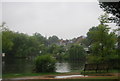
8
River Thames, Thames Ditton
The gap between Thames Ditton Island on the left and Boyle Farm Island has silted up. In the mid 90s it was possible to row a gig through the gap but you can now walk it and keep your feet dry.
Image: © Hugh Venables
Taken: 26 Dec 2011
0.05 miles
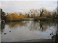
10
Boyle Farm Island
The downstream end of the little island (which is immediately downstream from Thames Ditton Island) seen from the Thames Path.
Image: © Derek Harper
Taken: 29 May 2016
0.05 miles