IMAGES TAKEN NEAR TO
Old Loans Road, KILMARNOCK, KA2 9DD
Introduction
This page details the photographs taken nearby to Old Loans Road, KA2 9DD by members of the Geograph project.
The Geograph project started in 2005 with the aim of publishing, organising and preserving representative images for every square kilometre of Great Britain, Ireland and the Isle of Man.

There are currently over 7.5m images from over14,400 individuals and you can help contribute to the project by visiting https://www.geograph.org.uk
Image Map
Images are licensed for reuse under creativecommons.org/licenses/by-sa/2.0
Notes
- Clicking on the map will re-center to the selected point.
- The higher the marker number, the further away the image location is from the centre of the postcode.
Image Listing (20 Images Found)
Images are licensed for reuse under creativecommons.org/licenses/by-sa/2.0
Image
Details
Distance
2
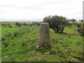
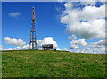
Wardlaw Hill trig point
The trig point lies on the northern edge of Wardlaw Hill Fort. Remains of a defence wall can still be seen around this small structure with a separate tiny mound on the northern point. The mapping surveyors as well as the original inhabitants recognised the value of this site as a viewpoint. The origin of the fort is uncertain but the 1857 OS Name Book ascribes it to the Roman period although no one is really sure. Other sources suggest prehistoric origins. The Old Statistical Account considered possible occupation of the site by the Vikings before the Battle of Largs.
Image: © Mary and Angus Hogg
Taken: 24 Aug 2020
0.10 miles
3
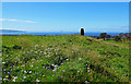
On Wardlaw Hill Fort
The trig point lies on the northern edge of Wardlaw Hill Fort. Remains of a defence wall can still be seen around this small structure with a separate tiny mound on the northern point, shown here by the white flowers. The origin of the fort is uncertain but the 1857 OS Name Book ascribes it to the Roman period although no one is really sure. Other sources suggest prehistoric origins.
Image: © Mary and Angus Hogg
Taken: 24 Aug 2020
0.10 miles
5
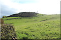
Remains of Harpercroft Fort defence wall
The 1857 OS map shows the Harpercroft site, close to Wardlaw Hill Fort, as a camp which, according to the 1857 OS Name Book, possibly dates from Roman times. This shot shows the north-western outer defences which take advantage of the steep slope.
Image: © Mary and Angus Hogg
Taken: 24 Aug 2020
0.12 miles
6
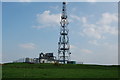
Radio mast
A radio mast,used for air traffic control,amongst other things.You may also notice the outline of the remains of a hill fort.
Image: © Scott
Taken: 8 May 2008
0.15 miles
7
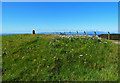
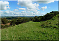
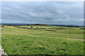
Towards Hallyards
Looking across the farmland of Kyle in lowland Ayrshire towards Hallyards Farm, which lies in the next square. A mid-August view from the western end of Wardlaw Hill.
Image: © Mary and Angus Hogg
Taken: 24 Aug 2020
0.17 miles
8
Communications mast at Harpercroft
The 1857 OS map shows the site at Harpercroft as a camp which, according to the 1857 OS Name Book, possibly dates from Roman times. Other sources suggest prehistoric origins. This view shows the platform in the middle of the site inside an inner defensive wall.
Image: © Mary and Angus Hogg
Taken: 24 Aug 2020
0.18 miles
10
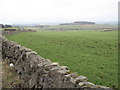
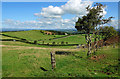
Wall and Field
Taken from spot height 125.
Image: © wfmillar
Taken: 4 Feb 2007
0.19 miles