IMAGES TAKEN NEAR TO
Seaforth Road, MUIR OF ORD, IV6 7TA
Introduction
This page details the photographs taken nearby to Seaforth Road, IV6 7TA by members of the Geograph project.
The Geograph project started in 2005 with the aim of publishing, organising and preserving representative images for every square kilometre of Great Britain, Ireland and the Isle of Man.

There are currently over 7.5m images from over14,400 individuals and you can help contribute to the project by visiting https://www.geograph.org.uk
Image Map
Images are licensed for reuse under creativecommons.org/licenses/by-sa/2.0
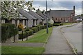
Notes
- Clicking on the map will re-center to the selected point.
- The higher the marker number, the further away the image location is from the centre of the postcode.
Image Listing (116 Images Found)
Images are licensed for reuse under creativecommons.org/licenses/by-sa/2.0
Image
Details
Distance
2
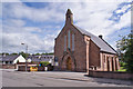
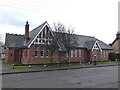
Parish Church East, Muir of Ord
Located in Seaforth Road. Once the United Free Church of Urray this became Urray East Church in 1929. It serves the united parishes of Urray and Kilchrist.
Image: © Richard Dorrell
Taken: 17 Jun 2014
0.03 miles
3
Urray East Church
According to another contributor it was formerly a Free Church Image, and a local history site confirms it became part of the Church of Scotland in 1929.
Image: © Stephen Craven
Taken: 5 Jul 2019
0.03 miles
4
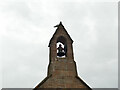
Urray East Church - bell
The church has a single bell in a turret at its west end. For context see Image
Image: © Stephen Craven
Taken: 5 Jul 2019
0.03 miles
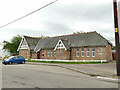
6
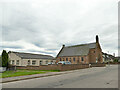
Village Hall, Muir of Ord
Community owned hall located in Seaforth Road.
Another view (without the electricity pole): Image
Image: © Richard Dorrell
Taken: 17 Jun 2014
0.05 miles
7
Muir of Ord village hall
The hall is in Seaforth Road. It appears on the 1906 map, and judging from its appearance was probably built not long before that. See also Image taken in 2014 - the two small trees in front of the hall have since been removed, probably as part of the 2018 renovation of the building funded by the Highland Council.
Image: © Stephen Craven
Taken: 5 Jul 2019
0.05 miles
8

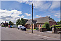
Fairmuir Road
A quiet residential street conveniently near the railway station.
Image: © Anne Burgess
Taken: 24 Jun 2021
0.06 miles
9
Old Bank Buildings, Balvaird Road
The bank is shown as such on the 1906 map but offers no clue to which banking company traded here. See also Image
Image: © Stephen Craven
Taken: 5 Jul 2019
0.06 miles
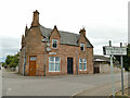
10
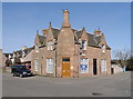
Old Bank Buildings, Seaforth Road
On the corner of Seaforth Road and Balvaird Road, in Muir of Ord.
From the name, presumably this was once a bank. I don't know anything about the history, or when it was last used as a bank. It looks like it is now housing.
Image: © Craig Wallace
Taken: 27 Mar 2017
0.06 miles