IMAGES TAKEN NEAR TO
FORRES, IV36 2RN
Introduction
This page details the photographs taken nearby to IV36 2RN by members of the Geograph project.
The Geograph project started in 2005 with the aim of publishing, organising and preserving representative images for every square kilometre of Great Britain, Ireland and the Isle of Man.

There are currently over 7.5m images from over14,400 individuals and you can help contribute to the project by visiting https://www.geograph.org.uk
Image Map
Images are licensed for reuse under creativecommons.org/licenses/by-sa/2.0
Notes
- Clicking on the map will re-center to the selected point.
- The higher the marker number, the further away the image location is from the centre of the postcode.
Image Listing (18 Images Found)
Images are licensed for reuse under creativecommons.org/licenses/by-sa/2.0
Image
Details
Distance
1
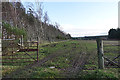
Field Entrance at Califer
The field awaits preparation for the next crop.
Image: © Anne Burgess
Taken: 2 Jan 2020
0.11 miles
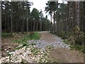
4
Califer Hill
Most of the trees at the viewpoint have been planted to commemorate people who wouldn't have wanted a gravestone in a conventional cemetery.
Image: © Anne Burgess
Taken: 3 Dec 2020
0.19 miles
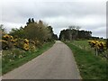
5
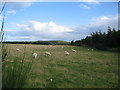
Grazing land near Greens of Burgie
A view looking to the southeast over grazing land near Greens of Burgie. The communications tower at Burgiehill can be seen in the distance.
Image: © Phil Williams
Taken: 2 Sep 2007
0.19 miles
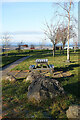
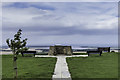
6
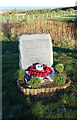
RAF Memorial
The stone commemorates three RAF officers lost in an accident on 3 July 2012.
Image: © Anne Burgess
Taken: 3 Dec 2020
0.21 miles
7
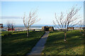
Califer Viewpoint
The circular dyke has a toposcope mounted on it to identify the places you can see from here.
Image: © Anne Burgess
Taken: 3 Dec 2020
0.21 miles
8
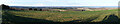
View from Califer Viewpoint
You can make out the almost landlocked Findhorn Bay on the right, and snow-covered hills in the northern Highlands beyond the Moray Firth.
Image: © Anne Burgess
Taken: 3 Dec 2020
0.21 miles
9
Viewpoint on Califer Hill
Findhorn to the right of the viewpoint.
Image: © Peter Moore
Taken: 31 Aug 2013
0.22 miles
10
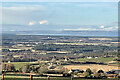
View from Califer Hill
This was taken by my companion, using her brand-new mobile phone. In the foreground is Upper Califer, and further down and to the left is the ruined tower of Blervie Castle. Almost in line with it, Brodie Castle stands out in the sunlight. Further away is the inner Moray Firth, with the cliffs of the Black Isle on the far side, and snow-capped Ben Wyvis on the skyline. This is part of a wider view taken with the phone in landscape orientation, but it seems to truncate the image when it is sent.
Image: © Hazel Milne
Taken: 3 Dec 2020
0.22 miles