IMAGES TAKEN NEAR TO
Macewen Drive, INVERNESS, IV2 3LH
Introduction
This page details the photographs taken nearby to Macewen Drive, IV2 3LH by members of the Geograph project.
The Geograph project started in 2005 with the aim of publishing, organising and preserving representative images for every square kilometre of Great Britain, Ireland and the Isle of Man.

There are currently over 7.5m images from over14,400 individuals and you can help contribute to the project by visiting https://www.geograph.org.uk
Image Map
Images are licensed for reuse under creativecommons.org/licenses/by-sa/2.0
Notes
- Clicking on the map will re-center to the selected point.
- The higher the marker number, the further away the image location is from the centre of the postcode.
Image Listing (38 Images Found)
Images are licensed for reuse under creativecommons.org/licenses/by-sa/2.0
Image
Details
Distance
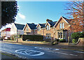
1
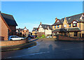
Kingsmills Park
A cul-de-sac of modern houses.
Image: © Anne Burgess
Taken: 25 Dec 2022
0.11 miles
3
Fraser Park and Pavilion
The porticoed building is the pavilion beside what I am told is the cricket pitch in the Fraser Park.
Image: © Anne Burgess
Taken: 25 Dec 2022
0.13 miles
4
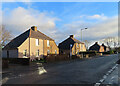
Kingsmills Road
Semidetached former council houses with slightly bizarre lean-to sides.
Image: © Anne Burgess
Taken: 25 Dec 2022
0.13 miles
5
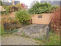
The Broad Stone, Kingsmills Road
A large broad stone, dating from before the 15th century. It has a hole in the middle, which probably supported a pillar or town cross. It may have marked a well or the burgh boundary.
The area behind was Kingsmills Park football ground, home of Inverness Thistle FC. That was demolished in the 1990s, and replaced with housing.
Image: © Craig Wallace
Taken: 3 Nov 2017
0.14 miles
6
Inverness Broad Stone
Located on Kingsmills Road the Broad Stone dates from before the 15th Century. the hole was thought to have supported a pillar or stone cross
Image: © valenta
Taken: 8 Nov 2018
0.14 miles
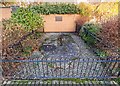
7
Broad Stone
The stone is thought to have marked the boundary of the mediaeval city. See https://canmore.org.uk/site/13523/inverness-broad-stone for additional information and Image] for the plaque in the dyke above the stone.
Image: © Anne Burgess
Taken: 25 Dec 2022
0.14 miles
8
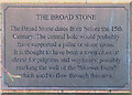
Plaque at the Broad Stone
The plaque is built into the dyke behind Image
Image: © Anne Burgess
Taken: 25 Dec 2022
0.14 miles
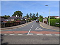
9
Darnaway Road
The east end of the street, where it meets Kingsmills Road.
Image: © Anne Burgess
Taken: 25 Dec 2022
0.15 miles
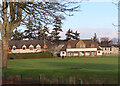
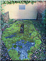
10

Foggy morning in Fraser Park
A view across Fraser Park. The park is used as a cricket pitch, this is the home of Highland Cricket Club. The cricket pavilion is visible on the left, with a line of trees along the park edge to the right.
Image: © Craig Wallace
Taken: 17 Jan 2014
0.17 miles