IMAGES TAKEN NEAR TO
Kingsmills Road, INVERNESS, IV2 3LD
Introduction
This page details the photographs taken nearby to Kingsmills Road, IV2 3LD by members of the Geograph project.
The Geograph project started in 2005 with the aim of publishing, organising and preserving representative images for every square kilometre of Great Britain, Ireland and the Isle of Man.

There are currently over 7.5m images from over14,400 individuals and you can help contribute to the project by visiting https://www.geograph.org.uk
Image Map (Loading...)


Getting Data...Please wait
Leaflet Map data © OpenStreetMap
Images are licensed for reuse under creativecommons.org/licenses/by-sa/2.0
Notes
- Clicking on the map will re-center to the selected point.
- The higher the marker number, the further away the image location is from the centre of the postcode.
Image Listing (48 Images Found)
Images are licensed for reuse under creativecommons.org/licenses/by-sa/2.0
Image
Details
Distance
1
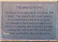
Plaque at the Broad Stone
The plaque is built into the dyke behind Image
Image: © Anne Burgess
Taken: 25 Dec 2022
0.02 miles
2
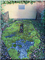
Broad Stone
The stone is thought to have marked the boundary of the mediaeval city. See https://canmore.org.uk/site/13523/inverness-broad-stone for additional information and Image] for the plaque in the dyke above the stone.
Image: © Anne Burgess
Taken: 25 Dec 2022
0.02 miles
3
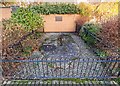
Inverness Broad Stone
Located on Kingsmills Road the Broad Stone dates from before the 15th Century. the hole was thought to have supported a pillar or stone cross
Image: © valenta
Taken: 8 Nov 2018
0.03 miles
4
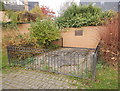
The Broad Stone, Kingsmills Road
A large broad stone, dating from before the 15th century. It has a hole in the middle, which probably supported a pillar or town cross. It may have marked a well or the burgh boundary.
The area behind was Kingsmills Park football ground, home of Inverness Thistle FC. That was demolished in the 1990s, and replaced with housing.
Image: © Craig Wallace
Taken: 3 Nov 2017
0.04 miles
5
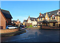
Kingsmills Park
A cul-de-sac of modern houses.
Image: © Anne Burgess
Taken: 25 Dec 2022
0.04 miles
6
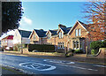
Darnaway Road
The east end of the street, where it meets Kingsmills Road.
Image: © Anne Burgess
Taken: 25 Dec 2022
0.05 miles
7
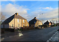
Kingsmills Road
Semidetached former council houses with slightly bizarre lean-to sides.
Image: © Anne Burgess
Taken: 25 Dec 2022
0.07 miles
9
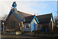
St John the Evangelist
This Scottish Episcopal Church has had a makeover with blue paint. Compare with Image], taken not quite three years ago. Designed by Ross and MacBeth as St Columba's Mission Chapel in 1890-1891 and extended by them after being taken over by the congregation of an earlier St John's Church in Church Street. It contains stained glass and furnishings from old St John's.
Image: © Anne Burgess
Taken: 25 Dec 2016
0.12 miles
10
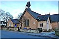
Church Of St John The Evangelist
This church, located on Southside Road, is a Scottish Episcopalian establishment.
Image: © Mary and Angus Hogg
Taken: 24 Feb 2014
0.12 miles