IMAGES TAKEN NEAR TO
The Tye, IPSWICH, IP6 8JE
Introduction
This page details the photographs taken nearby to The Tye, IP6 8JE by members of the Geograph project.
The Geograph project started in 2005 with the aim of publishing, organising and preserving representative images for every square kilometre of Great Britain, Ireland and the Isle of Man.

There are currently over 7.5m images from over14,400 individuals and you can help contribute to the project by visiting https://www.geograph.org.uk
Image Map
Images are licensed for reuse under creativecommons.org/licenses/by-sa/2.0
Notes
- Clicking on the map will re-center to the selected point.
- The higher the marker number, the further away the image location is from the centre of the postcode.
Image Listing (10 Images Found)
Images are licensed for reuse under creativecommons.org/licenses/by-sa/2.0
Image
Details
Distance
1
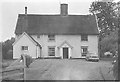
Moat Farm, Barking Tye in 1964
The house is moated with the moat along the left hand side of the house (as viewed) and at the back. We were visiting relatives (who still live here) for the day from our house in Berkhamsted. My father's Rover 100 is standing outside the house. It would be considered a classic car nowadays but when he came to sell it in 1967 no private buyer was interested so he had to sell it to a garage.
Image: © John Baker
Taken: 14 Jun 1964
0.02 miles
2
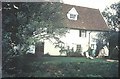
Moat Farm, Barking Tye in 1966
The darker green at the front of the lawn is the bank of the moat, which also extends down the sides of the house
Image: © John Baker
Taken: 3 Sep 1966
0.06 miles
3
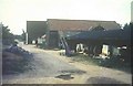
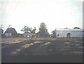
Outbuildings at Moat Farm, Barking Tye in 1966
Image: © John Baker
Taken: 3 Sep 1966
0.06 miles
4
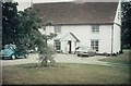
Moat Farm, Barking Tye in 1972
Along the right side wall of the house, four piles (the tops of which can be seen) were driven into the ground to stabilise the building.
Image: © John Baker
Taken: Unknown
0.07 miles
5
Moat Farm. Barking Tye in 1966
The blackened ground shows that the stubble had been set alight after harvesting, as was the custom in those days. The farm buildings also include the farmhouse, which can be seen in the background.
Image: © John Baker
Taken: 3 Sep 1966
0.07 miles
6
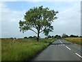
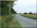
Village sign for Ringshall
On the flat land between Barking Tye and Ringshall, the B1078 is straight. It bends to the left in the bushes ahead, but there is a footpath which follows the same straight line
Image: © David Smith
Taken: 19 Jun 2014
0.08 miles
8
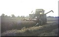
Combining at Moat Farm, Barking Tye in 1966
Image: © John Baker
Taken: 3 Sep 1966
0.16 miles
9
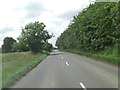
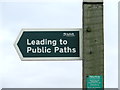
Leading To Public Footpaths
Sign at the side of the B1078 near to Ringshall Stocks, Suffolk. For close up view of the sign see http://www.geograph.org.uk/photo/2566532
Image: © Keith Evans
Taken: 21 Aug 2011
0.20 miles
10
Footpath Sign
Close up view of a footpath sign near to Ringshall Stocks, Suffolk for overall view see http://www.geograph.org.uk/photo/2566527
Image: © Keith Evans
Taken: 21 Aug 2011
0.20 miles