IMAGES TAKEN NEAR TO
Canterbury Avenue, ILFORD, IG1 3NG
Introduction
This page details the photographs taken nearby to Canterbury Avenue, IG1 3NG by members of the Geograph project.
The Geograph project started in 2005 with the aim of publishing, organising and preserving representative images for every square kilometre of Great Britain, Ireland and the Isle of Man.

There are currently over 7.5m images from over14,400 individuals and you can help contribute to the project by visiting https://www.geograph.org.uk
Image Map
Images are licensed for reuse under creativecommons.org/licenses/by-sa/2.0
Notes
- Clicking on the map will re-center to the selected point.
- The higher the marker number, the further away the image location is from the centre of the postcode.
Image Listing (14 Images Found)
Images are licensed for reuse under creativecommons.org/licenses/by-sa/2.0
Image
Details
Distance
1
NEW
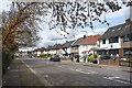
Wanstead Park Road
Residential on the opposite side only. On this side is a strip of woodland separating us from the North Circular Road.
Wanstead Park Road is part of the route of the Roding Valley Way which follows the River Roding, on and off, for 10 kms or so between Woodford and Ilford.
This is one of the "off" bits with the river being on the other side of the North Circular Road. A very pleasant riverside walk does exist. It's through Wanstead Park and would be a much nicer route for the Roding Valley Way except that there is no way out of the park at its northern end.
Image: © Des Blenkinsopp
Taken: 2 Apr 2024
0.12 miles
2
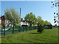
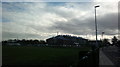
Corner of sports field
The small brick building has a corrugated iron roof and is of unknown purpose.
Image: © Robin Webster
Taken: 9 Apr 2011
0.17 miles
3
View of houses on Wanstead Lane from The Drive
Looking north-northeast.
Image: © Robert Lamb
Taken: 22 Nov 2013
0.18 miles
4
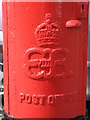
Edward VIII postbox, Wanstead Park Road / Carlisle Gardens - royal cipher
See Image
Image: © Mike Quinn
Taken: 30 Jul 2008
0.19 miles
5
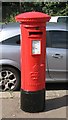
Edward VIII postbox, Wanstead Park Road / Carlisle Gardens
The location of this postbox is shown in Image
Image: © Mike Quinn
Taken: 30 Jul 2008
0.20 miles
6
View of Cranbrook Primary School from The Drive
Looking south-southeast.
Image: © Robert Lamb
Taken: 22 Nov 2013
0.20 miles
7
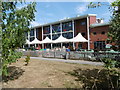
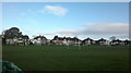
Cranbrook Primary School
The school, which also incorporates a children's centre, is seen here from The Drive.
Image: © Marathon
Taken: 24 Aug 2016
0.20 miles
8
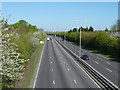
A406 North Circular Road
Looking anticlockwise.
Image: © Robin Webster
Taken: 9 Apr 2011
0.20 miles
9
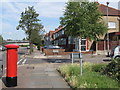
Wanstead Park Road / Carlisle Gardens
Shows the location of Image
Image: © Mike Quinn
Taken: 30 Jul 2008
0.21 miles
10
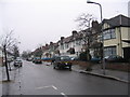
Redbridge residential street
This residential street, just off The Drive and close to the Eastern Avenue, is typical of much of Redbridge and Gants Hill.
Image: © Andrew Dann
Taken: 8 Jan 2006
0.22 miles