IMAGES TAKEN NEAR TO
Uphall Road, ILFORD, IG1 2JJ
Introduction
This page details the photographs taken nearby to Uphall Road, IG1 2JJ by members of the Geograph project.
The Geograph project started in 2005 with the aim of publishing, organising and preserving representative images for every square kilometre of Great Britain, Ireland and the Isle of Man.

There are currently over 7.5m images from over14,400 individuals and you can help contribute to the project by visiting https://www.geograph.org.uk
Image Map
Images are licensed for reuse under creativecommons.org/licenses/by-sa/2.0
Notes
- Clicking on the map will re-center to the selected point.
- The higher the marker number, the further away the image location is from the centre of the postcode.
Image Listing (61 Images Found)
Images are licensed for reuse under creativecommons.org/licenses/by-sa/2.0
Image
Details
Distance
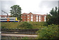
3

Elevated and ground level tracks at the approach to Barking Station
View from charter train on high level railway track above ground level lines
Image: © Roger Templeman
Taken: 17 Sep 2011
0.12 miles
5
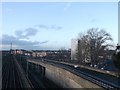
Railway line to Manor Park
As seen from the footbridge between North Street and Loxford Road.
The lines on the left carry the District Line to East Ham (tube-line), the line to Woodgrange Park (the Overground Line), and the railway line to Fenchurch Street.
The line on the right carries the High Speed link to Stratford.
Image: © David Anstiss
Taken: 16 Dec 2012
0.14 miles
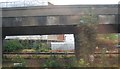
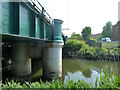
6
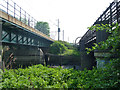
Between bridges, River Roding
The District Line bridge is on the right, the Barking - Forest Gate line on the left.
Image: © Robin Webster
Taken: 24 Apr 2011
0.16 miles
7
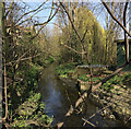
Secret River
Barking Park. Stream View from Ilford Lane through the railings. Blocked off. Tranquil with clear water
Image: © Gita Patel
Taken: 23 Oct 2021
0.16 miles
8
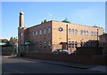
Barking: Al-Madina Mosque
Located at the east end of Victoria Road at its junction with Ilford Lane.
Image: © Nigel Cox
Taken: 30 Oct 2007
0.16 miles
9
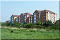
Flats, Barking
Overlooking the River Roding which is hidden below the bushes.
Image: © Robin Webster
Taken: 24 Apr 2011
0.16 miles
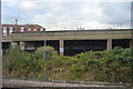
10
River Roding by railway bridge
The bridge carries the Fenchurch Street lines west of Barking station.
Image: © Robin Webster
Taken: 24 Apr 2011
0.16 miles