IMAGES TAKEN NEAR TO
Meadow Road, IG11 9FH
Introduction
This page details the photographs taken nearby to Meadow Road, IG11 9FH by members of the Geograph project.
The Geograph project started in 2005 with the aim of publishing, organising and preserving representative images for every square kilometre of Great Britain, Ireland and the Isle of Man.

There are currently over 7.5m images from over14,400 individuals and you can help contribute to the project by visiting https://www.geograph.org.uk
Image Map
Images are licensed for reuse under creativecommons.org/licenses/by-sa/2.0
Notes
- Clicking on the map will re-center to the selected point.
- The higher the marker number, the further away the image location is from the centre of the postcode.
Image Listing (81 Images Found)
Images are licensed for reuse under creativecommons.org/licenses/by-sa/2.0
Image
Details
Distance
1
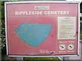
Rippleside Cemetery sign
Off the A123 Ripple Road
Image: © Geographer
Taken: 28 Apr 2009
0.05 miles
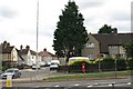
3
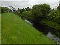
Mayes Brook looking towards Ripple Road
The Mayes Brook originates just to the north of Chadwell Heath, although the upper reaches now run mostly underground. Just north of here, on the other side of Ripple Road the Mayes Brook flows underground near Rippleside Cemetery. The Mayes Brook flows into the River Roding at Barking Creek.
The open space alongside the Mayes Brook here can only be entered from Ripple Road as the railway and the A13 block the other end.
Image: © Marathon
Taken: 29 Jun 2016
0.06 miles
4
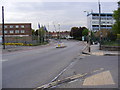
A123 Ripple Road, Barking
Looking towards the junction with Upney Lane near Rippleside Cemetery
Image: © Geographer
Taken: 28 Apr 2009
0.06 miles
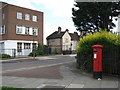
6
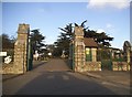
The entrance to Rippleside Cemetery, Barking
Image: © David Howard
Taken: 21 Oct 2017
0.06 miles
7
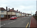
Ripple Road / Blake Avenue
Shows the location of Image
Image: © Mike Quinn
Taken: 21 Aug 2008
0.07 miles
8
Rippleside Cemetery, near Barking
This photograph was taken at the entrance to Rippleside Cemetery, in east London's outer suburbs.
Image: © Malc McDonald
Taken: 28 Aug 2017
0.07 miles
9
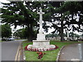
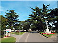
The war memorial in Rippleside Cemetery
Rippleside Cemetery was set up by Barking Parish Burial Board. It was opened in 1886, the first burial taking place in October of that year. The original 19th century lodge, gates and some original railings remain, together with the chapel. The burial ground was extended to the east just after the Second World War. For a fuller description see http://www.londongardensonline.org.uk/gardens-online-record.asp?ID=BAD019
The war memorial faces the main entrance in Ripple Road.
Image: © Marathon
Taken: 29 Jun 2016
0.07 miles
10
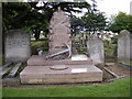
The Family Vault of Robert Hewett at Rippleside Cemetery
Off the A123 Ripple Road
Image: © Geographer
Taken: 28 Apr 2009
0.07 miles