IMAGES TAKEN NEAR TO
Burney Drive, LOUGHTON, IG10 2DY
Introduction
This page details the photographs taken nearby to Burney Drive, IG10 2DY by members of the Geograph project.
The Geograph project started in 2005 with the aim of publishing, organising and preserving representative images for every square kilometre of Great Britain, Ireland and the Isle of Man.

There are currently over 7.5m images from over14,400 individuals and you can help contribute to the project by visiting https://www.geograph.org.uk
Image Map (Loading...)


Getting Data...Please wait
Leaflet Map data © OpenStreetMap
Images are licensed for reuse under creativecommons.org/licenses/by-sa/2.0
Notes
- Clicking on the map will re-center to the selected point.
- The higher the marker number, the further away the image location is from the centre of the postcode.
Image Listing (19 Images Found)
Images are licensed for reuse under creativecommons.org/licenses/by-sa/2.0
Image
Details
Distance
1
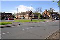
Junction of Willingale Road and Willingale Close
Image: © Roger Templeman
Taken: 21 Apr 2012
0.09 miles
2
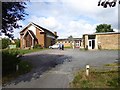
Mannock Drive, Debden
Part of the residential estate; seen from the entrance to Trinity chapel
Image: © David Smith
Taken: 10 Aug 2016
0.10 miles
4
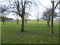
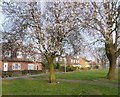
Jessel Green
Debden takes its name from the ancient manor of Debden, which lay at its northern end around Debden Green. The Debden Estate was constructed between 1947 and 1952 by the London County Council after they bought 644 acres from John Maitland.
The hilltop at Jessel Green is one of the highest points on the Debden Estate. Otherwise this open space is rather featureless.
Image: © Marathon
Taken: 13 Mar 2015
0.11 miles
5
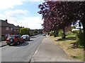
Blossom on Jessel Drive
Debden takes its name from the ancient manor of Debden, which lay at its northern end around Debden Green. The Debden Estate was constructed between 1947 and 1952 by the London County Council after they bought 644 acres from John Maitland.
This is on the east side of Jessel Green looking towards Willingale Road.
Image: © Marathon
Taken: 13 Mar 2015
0.11 miles
6
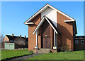
Trinity church, Mannock Drive, Debden
A chapel used by an independent congregation
Image: © David Smith
Taken: 10 Aug 2016
0.11 miles
9
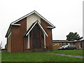
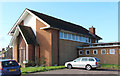
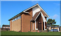
Trinity Church, Debden
Trinity Church stands at the top of the hill on the western side of Mannock Drive. It is a Methodist church building with a joint Anglican/ Methodist congregation, erected to serve the housing estate which forms the eastern edges of Debden. (Text courtesy of Peter Kessler http://www.historyfiles.co.uk/ChurchesBritain/East/Essex_Epping05.htm)
The Debden Estate was constructed between 1947 and 1952 although the church may be a little later.
Image: © Stephen Craven
Taken: 19 Feb 2011
0.12 miles
10
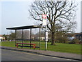
Bus stop on Burney Drive
Debden takes its name from the ancient manor of Debden, which lay at its northern end around Debden Green. The Debden Estate was constructed between 1947 and 1952 by the London County Council after they bought 644 acres from John Maitland.
The open space beyond the bus stop features a stream which is a tributary of the River Roding. This open parkland is continuous with the stream from Pyrles Lane to just beyond Willingale Road.
Image: © Marathon
Taken: 13 Mar 2015
0.14 miles