IMAGES TAKEN NEAR TO
Scout Bottom Lane, Scout Road, HEBDEN BRIDGE, HX7 5JS
Introduction
This page details the photographs taken nearby to Scout Bottom Lane, Scout Road, HX7 5JS by members of the Geograph project.
The Geograph project started in 2005 with the aim of publishing, organising and preserving representative images for every square kilometre of Great Britain, Ireland and the Isle of Man.

There are currently over 7.5m images from over14,400 individuals and you can help contribute to the project by visiting https://www.geograph.org.uk
Image Map
Images are licensed for reuse under creativecommons.org/licenses/by-sa/2.0
Notes
- Clicking on the map will re-center to the selected point.
- The higher the marker number, the further away the image location is from the centre of the postcode.
Image Listing (75 Images Found)
Images are licensed for reuse under creativecommons.org/licenses/by-sa/2.0
Image
Details
Distance
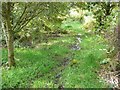
1
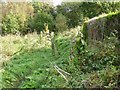
Hebden Royd Path 54 regains its proper line
The path has been pushed off-line by trees and bushes (see Image). Here it gets back to running alongside the property boundary.
Image: © Humphrey Bolton
Taken: 9 Oct 2012
0.01 miles
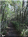
2
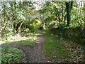
Hebden Royd Path 54
A pleasant stretch of the path alongside woodland. The path to the left is into private land.
Image: © Humphrey Bolton
Taken: 9 Oct 2012
0.02 miles
3

Scout Lane Primary School, Mytholmroyd
Image: © Alexander P Kapp
Taken: 1 Jul 2009
0.02 miles
4
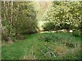
Woodland alongside Hebden Royd FP 54
On the 1905 map this was part of a block of fields, but on the 1930s edition most of this area had been turned into a large area of railway sidings. This in turn has been abandoned, and become woodland, which the owner evidently wants people to keep out of. The pond is no doubt more effective than the sign.
Image: © Humphrey Bolton
Taken: 9 Oct 2012
0.02 miles
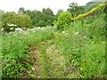
5
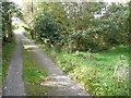
Footpath junction, Scout Bottom Lane
Scout Bottom Lane is an unadopted road and public footpath. The branch to New Road starts by going into a wet hollow.
Image: © Humphrey Bolton
Taken: 9 Oct 2012
0.03 miles
6
Hebden Royd Path 54 approaching Scout Bottom Lane
This soggy stretch appears just when you think that you have reached tarmac with dry feet.
Image: © Humphrey Bolton
Taken: 9 Oct 2012
0.04 miles
7

Pond off Scout Bottom Lane, Mytholmroyd
This does not appear on any old maps, so must be a recent creation.
Image: © Humphrey Bolton
Taken: 23 Jun 2011
0.06 miles
8
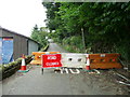
Road closure, Scout Road, Mytholomroyd
Parts of the road have become unsafe due to subsidence.
Image: © Humphrey Bolton
Taken: 19 Aug 2013
0.06 miles
9
Sustrans Route 66, Calder Valley
Here we are looking east towards Sowerby Bridge having just left Mytholmroyd. The railway line is to the left of the wire fence.
Image: © michael ely
Taken: 28 Sep 2008
0.07 miles
10
Hebden Royd Path 54.Mytholmroyd
Here the path was in danger of becoming overgrown but has been cleared. The right-of-way is straight, alongside the wall, but paths tend to acquire gentle curves.
Image: © Humphrey Bolton
Taken: 23 Jun 2011
0.08 miles