IMAGES TAKEN NEAR TO
Stoney Lane, HALIFAX, HX2 6EN
Introduction
This page details the photographs taken nearby to Stoney Lane, HX2 6EN by members of the Geograph project.
The Geograph project started in 2005 with the aim of publishing, organising and preserving representative images for every square kilometre of Great Britain, Ireland and the Isle of Man.

There are currently over 7.5m images from over14,400 individuals and you can help contribute to the project by visiting https://www.geograph.org.uk
Image Map
Images are licensed for reuse under creativecommons.org/licenses/by-sa/2.0
Notes
- Clicking on the map will re-center to the selected point.
- The higher the marker number, the further away the image location is from the centre of the postcode.
Image Listing (84 Images Found)
Images are licensed for reuse under creativecommons.org/licenses/by-sa/2.0
Image
Details
Distance
1
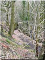
Footpath off Styes Lane, Luddenden Foot
This follows the stream, then turns right when it meets the railway, which it eventually crosses, goes over the river and up to the main road.
Image: © Humphrey Bolton
Taken: 27 Feb 2009
0.05 miles
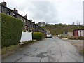
2
Styes Lane
Styes Lane is on the left, ascending towards the village of Sowerby.
The right hand fork gives access to Swamp Cottage and other local dwellings.
Image: © Chris Heaton
Taken: 4 Mar 2023
0.05 miles
3
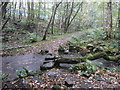
Stepping stones on Sowerby bridge FP67, Luddendenfoot
This was one of those days when it rained and rained. I came back two hours later and the water was almost covering the stones.
Image: © Humphrey Bolton
Taken: 19 Oct 2017
0.08 miles
4
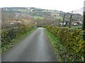
Lane below Swamp, near Finkle Street, Luddenden Foot
The reservoir is on the left, and Styes Lane comes in on the right. Warley is in the distance on the far side of the Calder valley.
Image: © Humphrey Bolton
Taken: 27 Feb 2009
0.09 miles
5
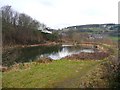
Reservoir, near Finkle Street, Luddenden Foot
This reservoir was used to supply the steam trains with water, and I think it is fed from the two small reservoirs at Higgin (SE034242).
Image: © Humphrey Bolton
Taken: 27 Feb 2009
0.09 miles
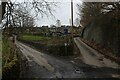
6
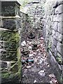
Valves next to the railway bridge, Luddenden Foot
Protected from traffic by a stone wall. It would seem likely that these are on a pipeline from the reservoir near Finkle Street to, perhaps, Cooper House Mills. Or maybe these are to do with supplying the railway water troughs too?
Image: © Humphrey Bolton
Taken: 27 Feb 2009
0.10 miles
7
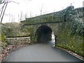
Railway Bridge, Stoney Lane, Luddenden Foot
This is bridge no. MVN2/146.
Image: © Humphrey Bolton
Taken: 27 Feb 2009
0.10 miles
9
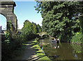
Rochdale Canal near Luddenden Foot
Looking towards bridge no.5. The towpath here forms part of the Sustrans Route 66.
Image: © michael ely
Taken: 28 Sep 2008
0.12 miles
10
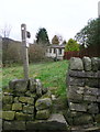
Sowerby Bridge FP67 at Styes Lane, Luddendenfoot
Old maps show the path going through the farmyard of Jack Hey, but now it goes round the farm on the north side.
Image: © Humphrey Bolton
Taken: 5 Dec 2017
0.12 miles