IMAGES TAKEN NEAR TO
Holderness Road, HULL, HU9 3EU
Introduction
This page details the photographs taken nearby to Holderness Road, HU9 3EU by members of the Geograph project.
The Geograph project started in 2005 with the aim of publishing, organising and preserving representative images for every square kilometre of Great Britain, Ireland and the Isle of Man.

There are currently over 7.5m images from over14,400 individuals and you can help contribute to the project by visiting https://www.geograph.org.uk
Image Map
Images are licensed for reuse under creativecommons.org/licenses/by-sa/2.0
Notes
- Clicking on the map will re-center to the selected point.
- The higher the marker number, the further away the image location is from the centre of the postcode.
Image Listing (416 Images Found)
Images are licensed for reuse under creativecommons.org/licenses/by-sa/2.0
Image
Details
Distance
1
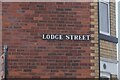
Lodge Street, Hull
https://www.geograph.org.uk/photo/6796626
Image: © Ian S
Taken: 29 Mar 2021
0.02 miles
2
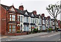
Holderness Road, Kingston upon Hull
Between Kelvin Street and Faraday Street, Nos.572 to 554 Holderness Road, an Edwardian terrace of ten, still in residential use. Half-timbered cross-gable roofs with pointed wooden finials and stepped two-storey front bays with lead roofs.
Image: © Bernard Sharp
Taken: 19 Jun 2013
0.02 miles
3
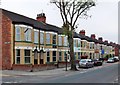
Holderness Road, Kingston upon Hull
Between Lodge Street and Kelvin Street, Nos.596 to 574 Holderness Road, an Edwardian terrace of 12 houses, still largely in residential use. Two-storey front bays with pentagonal roofs, though five have been removed.
Image: © Bernard Sharp
Taken: 19 Jun 2013
0.02 miles
4
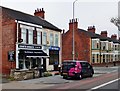
Holderness Road, Kingston upon Hull
Between the windmill at The Mill public house and Lodge Street, Nos.600 & 598 Holderness Road, Edwardian semi-detached houses, now in mixed use. Distinguished by lintels above first-floor windows and ornamental eave brackets.
Image: © Bernard Sharp
Taken: 19 Jun 2013
0.02 miles
5

Coronavirus lockdown, Kingston upon Hull
The nation was put into lockdown on 23 March 2020 in an unprecedented step to attempt to limit the spread of Corona Virus Disease 2019 (COVID-19). People were required to leave their homes only for going to work, essential shopping, medical appointments and daily exercise. Many businesses were ordered to be closed to maintain physical distancing.
The pandemic is, of course, worldwide and UNICEF has embarked upon a poster information campaign to highlight the extra difficulties of fighting the virus in a war zone. Displayed on bus shelter outside the Woodford Centre, Holderness Road.
Image: © Bernard Sharp
Taken: 21 Jun 2020
0.03 miles
7

Coronavirus lockdown, Kingston upon Hull
In the seven days to 13 November 2020, the city had recorded 761 coronavirus cases per 100,000 people, easily topping the table for the United Kingdom. The City Council is drawing the public's attention to the 'critical levels' as per this banner attached to the railings outside the Woodford Leisure Centre, Holderness Road.
Image: © Bernard Sharp
Taken: 19 Nov 2020
0.03 miles
8
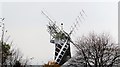
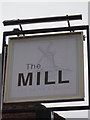
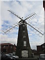
Holderness Road, Kingston upon Hull
The windmill at The Mill public house. Built circa 1820. For many years, the windmill stood without its cap, sails and fantail; although these have been restored, it is not a working mill. The last surviving windmill on Holderness Road and in the city as a whole. Viewed from East Park. Listed Building Grade II http://www.britishlistedbuildings.co.uk/en-387624-windmill-at-the-mill-public-house-
Image: © Bernard Sharp
Taken: 4 Nov 2012
0.03 miles
9
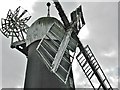
Holderness Road, Kingston upon Hull
The windmill at The Mill public house. Built circa 1820. For many years, the windmill stood without its cap, sails and fantail; although these have been restored, it is not a working mill. The last surviving windmill on Holderness Road and in the city as a whole. Listed Building Grade II http://www.britishlistedbuildings.co.uk/en-387624-windmill-at-the-mill-public-house-
Image: © Bernard Sharp
Taken: Unknown
0.03 miles
10
Holderness Corn Mill Holderness Road
Owned by Alfred West,Joseph Rank rented it three days a week to grind flour and the rest is history. In the car park of The Mill public house.
Image: © Martin Dawes
Taken: 25 Feb 2015
0.03 miles