IMAGES TAKEN NEAR TO
Station Road, BROUGH, HU15 1DZ
Introduction
This page details the photographs taken nearby to Station Road, HU15 1DZ by members of the Geograph project.
The Geograph project started in 2005 with the aim of publishing, organising and preserving representative images for every square kilometre of Great Britain, Ireland and the Isle of Man.

There are currently over 7.5m images from over14,400 individuals and you can help contribute to the project by visiting https://www.geograph.org.uk
Image Map
Images are licensed for reuse under creativecommons.org/licenses/by-sa/2.0
Notes
- Clicking on the map will re-center to the selected point.
- The higher the marker number, the further away the image location is from the centre of the postcode.
Image Listing (104 Images Found)
Images are licensed for reuse under creativecommons.org/licenses/by-sa/2.0
Image
Details
Distance
1
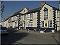
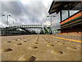
The Buccaneer, Brough
On Station Road, it was originally known simply as The Tavern. It became The Railway Tavern in 1840, and was renamed The Buccaneer in 1962, after the famous plane produced at the nearby Blackburn aircraft factory (now British Aerospace).
Image: © Paul Harrop
Taken: 16 Feb 2008
0.01 miles
2
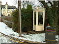
Kingston White Public Telephone Box in the Snow
On the corner of Station Road and Grassdale Park in Brough, East Yorkshire.
Image: © Road Engineer
Taken: 22 Dec 2003
0.01 miles
3
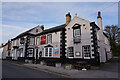
The Buccaneer public house, Station Road, Brough
Image: © Ian S
Taken: 28 Oct 2020
0.02 miles
4
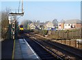
The Permanent Way, Brough, E Yorkshire
Even post Beeching, this station boasted four platforms and some sidings. The 17:12 departures (2) Monday to Friday took Hawker Siddeley employees home to Ferriby, Hessle and Hull on the slow train, or direct to Hull on the through train. Alas now, the station only has two platforms.
The photograph shows the Hull Trains Service departing west for Howden, Selby and on to London. Also both old and newer housing can be seen.
Image: © Peter Church
Taken: 12 Feb 2008
0.04 miles
5
The lowdown on Brough Station Platform
Taken at ground level, the lumps on the station platform's edge grips can be seen in the foreground.
Image: © Andy Beecroft
Taken: 2 Mar 2009
0.04 miles
6
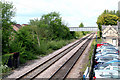
Brough: Railway, looking west
The railway through Brough was opened by the Hull and Selby Railway in 1840, Brough station opening at the same time. In 1872 the local company was absorbed by the North Eastern Railway, and then became part of the LNER in 1923.
Image: © Dr Neil Clifton
Taken: 17 May 2010
0.05 miles
7
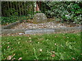
Old milestone
On Saltgrounds Road in Brough just south of the Ferry Inn, this milestone was restored by Elloughton and Brough Parish Council in 1983. There was an 8.3 mile turnpike between Brough Ferry and Newbald Holmes which was first enacted in 1771 and ended in 1872. This was part of a route between York and Lincoln which would use the ferry to cross the River Humber.
Image: © Chris Minto
Taken: 12 Sep 2021
0.05 miles
9
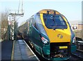
The Hull Trains Service leaves Brough
With modern rolling stock, the Hull Trains Hull to London Kings Cross service is regular, reliable and makes for a very pleasant journey. The train captured here is just leaving the station.
Image: © Peter Church
Taken: 12 Feb 2008
0.06 miles
10
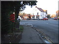
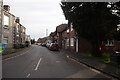
Station Road, Brough
Ferry Inn at the rear.
Showing position of Postbox No. HU15 207.
See Image] for postbox.
Image: © JThomas
Taken: 26 Jan 2018
0.06 miles