IMAGES TAKEN NEAR TO
Orchard View, ROSS-ON-WYE, HR9 7GL
Introduction
This page details the photographs taken nearby to Orchard View, HR9 7GL by members of the Geograph project.
The Geograph project started in 2005 with the aim of publishing, organising and preserving representative images for every square kilometre of Great Britain, Ireland and the Isle of Man.

There are currently over 7.5m images from over14,400 individuals and you can help contribute to the project by visiting https://www.geograph.org.uk
Image Map
Images are licensed for reuse under creativecommons.org/licenses/by-sa/2.0
Notes
- Clicking on the map will re-center to the selected point.
- The higher the marker number, the further away the image location is from the centre of the postcode.
Image Listing (131 Images Found)
Images are licensed for reuse under creativecommons.org/licenses/by-sa/2.0
Image
Details
Distance
1
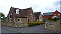
Orchard View, Lea
New housing development to the rear of the old primary school.
The name of the cul-de-sac is now obsolete as the apple orchard opposite was grubbed not long after the houses were built.
Image: © Jonathan Billinger
Taken: 17 May 2012
0.01 miles
2
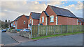
Old primary school, Lea
The building and its grounds were developed into housing several years prior to the photograph.
Image: © Jonathan Billinger
Taken: 24 Jul 2020
0.01 miles
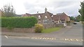
3
Village housing
This cluster of houses by the A40 at Lea are on land developed from the old village primary school.
Image: © Jonathan Billinger
Taken: 31 Mar 2022
0.02 miles
5
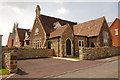
Former school at Lea
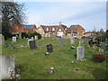
Now a dwelling. The cars in the distance are parked outside the new school which was opened in 2005. Taken from the nearby churchyard of the parish church of St. John the Baptist.
Image: © Pauline E
Taken: 14 Mar 2008
0.02 miles
6
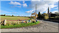
Signs by the entrance to Lea village hall
The traditional village signs announcing the Bonfire Night arrangements and 'Flicks in the Sticks'.
St. John the Baptist church is across the A40 road.
Image: © Jonathan Billinger
Taken: 28 Oct 2022
0.03 miles
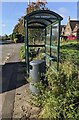
7
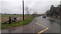
Wet bus stop, Lea
The posters by the A40 promote events taking place at Lea village hall including 'Flicks in the Sticks' and bingo.
Image: © Jonathan Billinger
Taken: 15 Feb 2020
0.03 miles
8
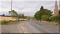
A40 at Lea church
An interesting but short-lived addition to the street furniture since Image a few months earlier.
The life-size image of a police officer with speed gun lasted about three days in this location by the bus stop opposite Lea church.
Image: © Jonathan Billinger
Taken: 23 Jul 2020
0.03 miles
9
Lea Church bus shelter, Herefordshire
Alongside the A40 opposite St John the Baptist Church. https://www.geograph.org.uk/photo/3422275
In October 2024 the shelter is alongside a stop on Stagecoach
Route 33 to Gloucester and Route 746 to Cinderford.
Image: © Jaggery
Taken: 27 Oct 2024
0.03 miles
10
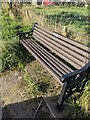
Platinum Jubilee Commemoration bench, Lea, Herefordshire
Located behind this https://www.geograph.org.uk/photo/7911700 bus shelter, the bench is alongside the A40.
https://www.geograph.org.uk/photo/7911706 to the plaque on the bench.
Image: © Jaggery
Taken: 27 Oct 2024
0.03 miles