IMAGES TAKEN NEAR TO
Weir End, ROSS-ON-WYE, HR9 6AL
Introduction
This page details the photographs taken nearby to HR9 6AL by members of the Geograph project.
The Geograph project started in 2005 with the aim of publishing, organising and preserving representative images for every square kilometre of Great Britain, Ireland and the Isle of Man.

There are currently over 7.5m images from over14,400 individuals and you can help contribute to the project by visiting https://www.geograph.org.uk
Image Map
Images are licensed for reuse under creativecommons.org/licenses/by-sa/2.0
Notes
- Clicking on the map will re-center to the selected point.
- The higher the marker number, the further away the image location is from the centre of the postcode.
Image Listing (13 Images Found)
Images are licensed for reuse under creativecommons.org/licenses/by-sa/2.0
Image
Details
Distance
1
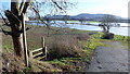
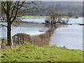
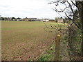
Footpath into the flood, 1
The path along the riverbank to Wilton via Moor Meadow becomes submerged only a few metres into this field by the A40.
A good view of the Chase Hill/Penyard outlier.
Image: © Jonathan Billinger
Taken: 16 Jan 2015
0.03 miles
3
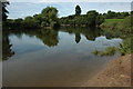
River Wye near Weirend
A bend in the River Wye near Weirend.
Image: © Philip Halling
Taken: 8 Aug 2009
0.08 miles
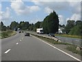
4
A40 at Weirend
Note the early dual carriageway construction with frequent gaps for access to frontage properties. The Armco barriers are a much later addition.
Image: © J Whatley
Taken: 31 Aug 2010
0.10 miles
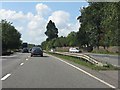
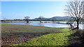
5
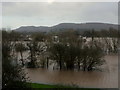
Flooded Wye
Looking along a hedgeline straight down to the river.
The river is high because of normal winter rain and snowmelt, particularly in Wales.
Image: © Jonathan Billinger
Taken: 16 Jan 2015
0.10 miles
6
Footpath into the flood, 2
Looking along the line of the path towards submerged Moor Meadow.
The spire of St. Mary's Ross-on-Wye can be seen distant left.
Image: © Jonathan Billinger
Taken: 16 Jan 2015
0.13 miles
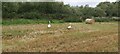
10
The Wye in flood, 2
Looking east from the same spot as Image The river itself should be between the nearest and next line of trees and bushes.
In the distance is the Penyard/Chase Hill with Ross-on-Wye below.
Image: © Jonathan Billinger
Taken: 12 Feb 2014
0.20 miles