IMAGES TAKEN NEAR TO
Much Marcle, LEDBURY, HR8 2NN
Introduction
This page details the photographs taken nearby to HR8 2NN by members of the Geograph project.
The Geograph project started in 2005 with the aim of publishing, organising and preserving representative images for every square kilometre of Great Britain, Ireland and the Isle of Man.

There are currently over 7.5m images from over14,400 individuals and you can help contribute to the project by visiting https://www.geograph.org.uk
Image Map
Images are licensed for reuse under creativecommons.org/licenses/by-sa/2.0
Notes
- Clicking on the map will re-center to the selected point.
- The higher the marker number, the further away the image location is from the centre of the postcode.
Image Listing (9 Images Found)
Images are licensed for reuse under creativecommons.org/licenses/by-sa/2.0
Image
Details
Distance
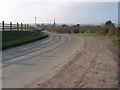
1
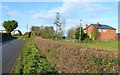
B4204 at Little Moorcourt
Looking towards Much Marcle.
Image: © Jonathan Billinger
Taken: 5 Dec 2008
0.01 miles
3
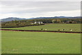
Little Moorend, Much Marcle
Moorcourt Cottages on the left.
On the horizon one can see the Malvern Hills with the Sommers' Obelisk on the far right.
Image: © Bob Embleton
Taken: 8 Oct 2011
0.04 miles
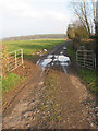
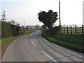
4
B4024 to Much Marcle
Near to Little Moor Court, which is behind the photographer.
Image: © Julian P Guffogg
Taken: 20 Apr 2015
0.06 miles
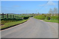
5
B4024 to Much Marcle
A large orchard lies behind the hedge in the centre. The transmitter on Ridgehill is usually very clearly seen from this point but the visibility today is poor.
Image: © Pauline E
Taken: 19 Dec 2007
0.08 miles
6
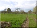
Orchard, Much Marcle
By Great Moorcroft on the B4024.
Image: © Richard Webb
Taken: 14 Apr 2016
0.08 miles
7
B4024 leaves Herefordshire
Heading for Gloucestershire. Once over the border the road is not so well-maintained.
Image: © Pauline E
Taken: 19 Dec 2007
0.10 miles
8
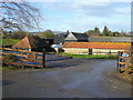
Great Moorcourt Farm
View north-west from the B4204.
Image: © Jonathan Billinger
Taken: 5 Dec 2008
0.19 miles
9
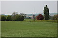
Farmland to the east of Much Marcle
The tower of Much Marcle church can be seen in the middle distance, beyond on the horizon is the transmitter on Ridge Hill.
Image: © Philip Halling
Taken: 29 Apr 2007
0.25 miles